

Worcester County coastal shores · Maryland
Assateague Island National Seashore — Maryland Ocean Beach
A sandy Atlantic barrier-island shore with developed North and South beach accesses, dunes and separate conditional OSV travel.
Good fit: Atlantic barrier-island beach and dune views from the developed North or South Beach arrivals. Details & sources ↗
Plan around: Use designated crossings and respect wildlife and closure signs. Check chair checkout and mat endpoints; OSV travel and camping require their own permissions. Details & sources ↗
- Parking
- Some details unconfirmed
Details & sources
- Dogs
- Dog zones & restrictions
Details & sources
- Restrooms
- Toilets & rinse details
Details & sources
- Lifeguards
- Dated staffing scope
Details & sources
- Key restrictions
- Check before you go
- Best for
- See beach overview
More planning facts: access, driving & fees
- Public access
- Public accessDetails & restrictions
- Beach driving
- Beach driving rulesDetails & restrictions
- Accessibility
- Route & equipment detailsDetails & restrictions
Choose an entrance
North Ocean Beach and South Ocean Beach
Use the Maryland Route 611/Verrazano Bridge entrance, Bayberry Drive and the signed North or South Ocean Beach parking/walkovers. No road connects this island district to Virginia.
Official route / restriction details ↗Review dates & updates
These are desk-research dates for each named category, including unresolved facts. They are not on-site inspections, current-opening confirmations or water-safety observations.
- identity location: research reviewed 2026-10-26 · verified
- summary description: research reviewed 2026-10-26 · verified
- known for: research reviewed 2026-10-26 · verified
- live weather: research reviewed 2026-10-26 · unresolved
- daily forecast: research reviewed 2026-10-26 · verified
- tides: research reviewed 2026-10-26 · unresolved
- surf rip forecast: research reviewed 2026-10-26 · unresolved
- official flags closures: research reviewed 2026-10-26 · unresolved
- water quality: research reviewed 2026-10-26 · unresolved
- public access: research reviewed 2026-10-26 · verified
- crowds: research reviewed 2026-10-26 · verified
- sand shoreline: research reviewed 2026-10-26 · verified
- surf: research reviewed 2026-10-26 · verified
- shelling: research reviewed 2026-10-26 · verified
- shark teeth: research reviewed 2026-10-26 · unresolved
- sea glass: research reviewed 2026-10-26 · unresolved
- driftwood: research reviewed 2026-10-26 · verified
- snorkeling: research reviewed 2026-10-26 · unresolved
- scuba: research reviewed 2026-10-26 · unresolved
- wildlife: research reviewed 2026-10-26 · verified
- accommodations: research reviewed 2026-10-26 · verified
- commercial activities rentals: research reviewed 2026-10-26 · verified
- alcohol rules: research reviewed 2026-10-26 · verified
- fire rules: research reviewed 2026-10-26 · verified
- camping rules: research reviewed 2026-10-26 · verified
- shore fishing rules: research reviewed 2026-10-26 · verified
- hours: research reviewed 2026-10-26 · verified
- dogs: research reviewed 2026-10-26 · verified
- lifeguards: research reviewed 2026-10-26 · verified
- restrooms showers: research reviewed 2026-10-26 · unresolved
- parking entry: research reviewed 2026-10-26 · verified
- accessibility: research reviewed 2026-10-26 · unresolved
- driving: research reviewed 2026-10-26 · unresolved
- public access rules: research reviewed 2026-10-26 · verified
- dining: research reviewed 2026-10-26 · verified
- history: research reviewed 2026-10-26 · verified
- managing authority: research reviewed 2026-10-26 · verified
- official source links: research reviewed 2026-10-26 · verified
- main photo: research reviewed 2026-10-26 · verified
- photo gallery: research reviewed 2026-10-26 · unresolved
- admission payment passes: research reviewed 2026-10-26 · verified
- plan your visit: research reviewed 2026-10-26 · verified
- check before you go: research reviewed 2026-10-26 · verified
- nearby beaches: research reviewed 2026-10-26 · verified
- closer look: research reviewed 2026-10-26 · verified
Report a change at Assateague Island National Seashore — Maryland Ocean Beach
Parking, route & accessibility evidence
Parking & entry: Parking & entry details. North Ocean Beach and South Ocean Beach have separate developed parking arrivals and pedestrian dune crossings. Use the signed walkover; do not park in the OSV access lanes.
Parking source ↗Accessibility: Route & equipment details. NPS lists 3 wheelchair sheds at North Beach and 1 at South Beach; mats at North Beach. Chairs require a helper, a valid driver license and key checkout, normally 2 hours. The current mat endpoint and remaining loose-sand/water gap are unverified.
Accessibility source ↗Open the county entrance directory ↗
Use the directory to check each entrance’s identity and status. Guide map pins are approximate shoreline locations, not turn-by-turn entrance directions or proof of current opening.
Known for
Atlantic beach visits, dunes, wild horses and permitted surf fishing; an OSV permit does not guarantee the drive-on route is currently open.
Rules & facilities
Check before you go
Confirm the responsible manager's latest closures, seasonal facilities, pet-zone boundaries and any needed permits. Check NWS hazards and official beach-water advisories separately. No photograph, static schedule or saved report guarantees today's opening, safe swimming or continuous access to water.
Admission, payment & passes
NPS 7-day private-vehicle entrance pass:$25; motorcycle:$20; annual Assateague pass:$45. Current page lists walk-in/bicycle entry:$0. Federal pass eligibility and camping/OSV/rental charges are separate; do not apply this pass to the DNR State Park.
What to bring & supporting visit details
Plan your visit
Choose the actual North or South Ocean Beach walkover, check current notices, carry water/sun protection, and keep food secure from wildlife. Fees, pet zones, staffing and accessible features must match that entrance; a planning map pin is not a navigation or safety assurance.
Public or private?
Public access
Who can visit: Use the Maryland Route 611/Verrazano Bridge entrance, Bayberry Drive and the signed North or South Ocean Beach parking/walkovers. No road connects this island district to Virginia.
Entry route, fees & access boundaries
- Manager / access authority
- National Park Service, Assateague Island National Seashore, Maryland District. State Park and Virginia management rules remain separate.
- Access basis
- Use the Maryland Route 611/Verrazano Bridge entrance, Bayberry Drive and the signed North or South Ocean Beach parking/walkovers. No road connects this island district to Virginia.
- Where to enter
- Use the Maryland Route 611/Verrazano Bridge entrance, Bayberry Drive and the signed North or South Ocean Beach parking/walkovers. No road connects this island district to Virginia.
- Fees & reservations
- NPS 7-day private-vehicle entrance pass:$25; motorcycle:$20; annual Assateague pass:$45. Current page lists walk-in/bicycle entry:$0. Federal pass eligibility and camping/OSV/rental charges are separate; do not apply this pass to the DNR State Park.
- Restrictions & exceptions
- Use developed arrivals and designated dune crossings, obey nesting/closure signs, and leave wildlife and protected resources undisturbed. Public shore access is distinct from permission for camping, OSV driving, boats or swimming at a launch.
- What this label covers
- Use the Maryland Route611/Verrazano Bridge entrance, Bayberry Drive and the signed North or South Ocean Beach parking/walkovers. No road connects this island district to Virginia.
Beach ownership, the route across land, public shoreline-use rights and access to facilities are separate questions. Rules vary by state and location. Use the identified public entrance or documented permission; neither a nearby resort nor an admission fee by itself establishes that a beach is private. A mapped beach is not permission to cross private property.
Access policy reviewed 2026-10-26. Not a live closure report or a property-boundary survey.
Allowed & prohibited activities
Alcohol: The NPS compendium prohibits alcohol in visitor centers/decks, ranger stations, nature trails, paved parking, boardwalks and interpretive programs. Virginia has a district-wide prohibition. Do not turn either statement into a blanket Maryland beach ban or unrestricted permission; posted restrictions apply.
Fires and grills: Maryland NPS fires are limited to the listed designated locations, including ocean beach below normal mean high tide, with receptacle/fuel/extinguishing rules. Lifeguarded areas and 100 yards north/south prohibit fires/cooking at all times. Bayside day-use sand is not automatically an authorized fire location.
Overnight camping: NPS camping requires a permit and a designated site. Tent camping or sleeping overnight on the beach is prohibited. Nearby Oceanside/Bayside campgrounds have separate reservations/fees; backcountry dates and closures must be checked independently.
Shore fishing: A valid Maryland saltwater fishing license is required subject to DNR exemptions/registration. Fishing is excluded from the regulated lifeguard-protected footprint; current signs and closures also apply. Old Ferry Landing crabbing and shellfishing have separate catch/size/season rules; do not fish from the Verrazano Bridge.
- Hours
- Hours & seasonal limits
The Maryland NPS district is open year-round,24 hours a day, subject to posted closures, habitat restrictions and separate permits. Visitor-center and ranger-desk hours are not beach access hours.
Assateague Island National Seashore — Maryland Ocean Beach · hours ↗ - Dogs on the beach
- Dog zones & restrictions
Pets are conditional in the Maryland district and must remain on a leash no longer than 6 feet. No pets on nature trails, backcountry campsites, north of State Park toward Ocean City Inlet, or the protected swimming footprint during its regulated season. The 2026 compendium specifies protected-area exclusion from Memorial Day weekend through September 30. Virginia prohibits pets and is outside this guide.
Assateague Island National Seashore — Maryland Ocean Beach · dogs ↗ - Lifeguards
- Dated staffing scope
NPS Current Conditions retrieved October 26 states no Maryland District lifeguards on duty. This is a dated manager notice, not a permanent assertion of no future seasonal coverage. The compendium defines a seasonal protected swim footprint but does not prove staff are present; no current tower roster is verified.
Assateague Island National Seashore — Maryland Ocean Beach · lifeguards ↗ - Restrooms
- Toilets & rinse details
NPS states that visitor centers, most nature trails, bathhouses and wayside exhibits are accessible. That confirms bathhouse facilities at district scope, not the current toilet/rinse inventory at every North/South crossing. Check with NPS for exact entrance facilities and seasonal running water.
Assateague Island National Seashore — Maryland Ocean Beach · restrooms showers ↗ - Access & beach rules
- Rules & restrictions
Use developed arrivals and designated dune crossings, obey nesting/closure signs, and leave wildlife and protected resources undisturbed. Public shore access is distinct from permission for camping, OSV driving, boats or swimming at a launch.
Assateague Island National Seashore — Maryland Ocean Beach · public access rules ↗ - Beach driving
- Beach driving rules
OSV use requires the separate NPS permit, designated route and required recovery equipment; Maryland vehicle capacity is 145. Current operation is unresolved: the conditions page has a generic open sentence and a dated October 11 closure for overwash. Do not drive onto the route until NPS confirms it is open. Pedestrians may use the South Beach boardwalk subject to current postings.
Assateague Island National Seashore — Maryland Ocean Beach · driving ↗
Conditions & activities Surf, sand, wildlife and suitability
Conditions at the beach
Local times use Eastern Time. No beach observation or saved forecast is displayed here. Forecast issue times, observation times, tide prediction dates and laboratory sample dates remain separate from desk-research dates. A linked source does not confirm current opening, a warning flag or swimming safety.
Weather observation
No exact on-beach weather observation or observation station is assigned here. The linked National Weather Service page provides forecast navigation; a forecast is a prediction, not an observed beach condition.
Daily forecast
The independently checked National Weather Service point-forecast link is available for this approximate planning point. No saved numeric forecast is displayed here. Forecast issue and prediction times are separate from source review and are not on-beach observations.
High & low tides
NOAA Ocean City Fishing Pier and Inlet metadata/predictions are available as regional reference sources. Their timing has not been independently calibrated to this exact sand entry. Use NOAA source navigation and correct dates; no precise beach high/low times, water depths or safe crossing times are asserted.
Surf & rip forecast
The NWS Maryland Beaches surf forecast explicitly includes Assateague, but the reviewed seasonal product says it is the last beach forecast of the season. Its October issue is historical and cannot describe today's risk. Consult current NWS hazards and on-site instructions.
Closures & warning flags
No dated observed hazard flag is verified. The October 25 NPS conditions page includes Maryland no-lifeguard notice and conflicting OSV open/closed wording. Check current manager notices; general district hours do not certify every shore or drive-on route open.
Water quality
EPA’s 2025-submitted Worcester roster includes North Beach Site#1(State Park Boundary), North Beach Site#2(Ranger Station) and Oceanside#3. Annual monitoring coverage is historical; it is not a current sample or advisory. Consult Maryland Healthy Beaches/current Worcester notices. Do not inherit another shore’s result.
National Weather Service point forecast ↗ for the independently reviewed approximate planning point.
Crowd meter
NPS warns Maryland/Virginia parking lots fill quickly on summer weekends and visitors arriving 11 am–2 pm may wait. This is district-level planning context, not a crowd count or guarantee at this particular sand entry.
Sand & sandcastles
A dynamic Atlantic sand beach backed by dunes. Wind, tides and storms move sand; no fixed beach width or sandcastle-suitability score is claimed.
Surfing profile
Surfboards are excluded from the designated lifeguard-protected swim zone during its operative season; beach conditions vary daily. No supported beginner/expert or wave-quality score is assigned.
Beachcombing
NPS allows hand-gathered shells free of animal habitation, up to 1 gallon per person per visit; shells from archaeological sites are excluded. This collection rule does not promise a particular abundance or species at an entrance.
No responsible source establishes this exact shore as a shark-tooth destination. No fossil-hunting expectation or suitability score is proposed.
Snorkeling & scuba diving
Typical underwater clarity and a documented shore-snorkeling route have not been established at this exact beach. Water color, calm-looking photos and laboratory bacterial results are not underwater visibility evidence; keep clarity and snorkeling Unrated.
No shore-scuba route has been verified here. Separately, Ocean City operator TLT Charters advertises boat-based wreck dives and requires divers to supply their equipment, including tanks. That offshore product is not an Assateague shore dive or snorkeling tour.
Clothing-optional, nudity & topless sunbathing
No official clothing-optional designation for this exact NPS Maryland beach was established in the reviewed current manager sources. Historical or informal nude use does not establish permission. Confirm the current rule with the responsible manager;this guide makes no permitted-nudity match.
Responsible source ↗ · Responsible source ↗
Nonsexual female-topless permission was researched separately for this exact NPS Maryland beach. The reviewed manager sources do not establish a specific permission or prohibition. General indecent-exposure wording does not by itself resolve that question;no positive topless match is made.
Water clarity & shore snorkeling
Typical clarity: Not yet assessed. Typical underwater clarity has not been assessed for this named shore. Water color, bacterial results and forecasts do not measure visibility.
Shore snorkeling not yet assessed. Typical underwater clarity and a documented shore-snorkeling route have not been established at this exact beach. Water color, calm-looking photos and laboratory bacterial results are not underwater visibility evidence; keep clarity and snorkeling Unrated.
Typical clarity describes how easily you may see through the water. It does not establish bacterial water quality, safe swimming, calm conditions or visibility today.
Evidence, location scope & review
Desk review 2026-10-26 · Assateague Island National Seashore — Maryland Ocean Beach. This is not an on-site inspection or a current conditions report.
Assateague Island National Seashore — Maryland Ocean Beach
Find clear-water and shore-snorkeling options ↗ · Report a change ↗
Shore & sky wildlife
Assateague NPS documents horses, white-tailed/sika deer, shorebirds, ghost crabs and estuarine wildlife. Protect nesting areas and keep a safe distance; these island habitat examples are not guaranteed sightings on this particular beach visit.
History & interesting facts
Assateague is a 37-mile island along the Maryland and Virginia coasts. Most of its Maryland district is managed by NPS; Maryland separately manages two miles as Assateague State Park. This guide covers only the Maryland NPS ocean parent.
A closer look
Photos of this beach and its surroundings. Select a photo to view it larger. These are recorded views, not live conditions.
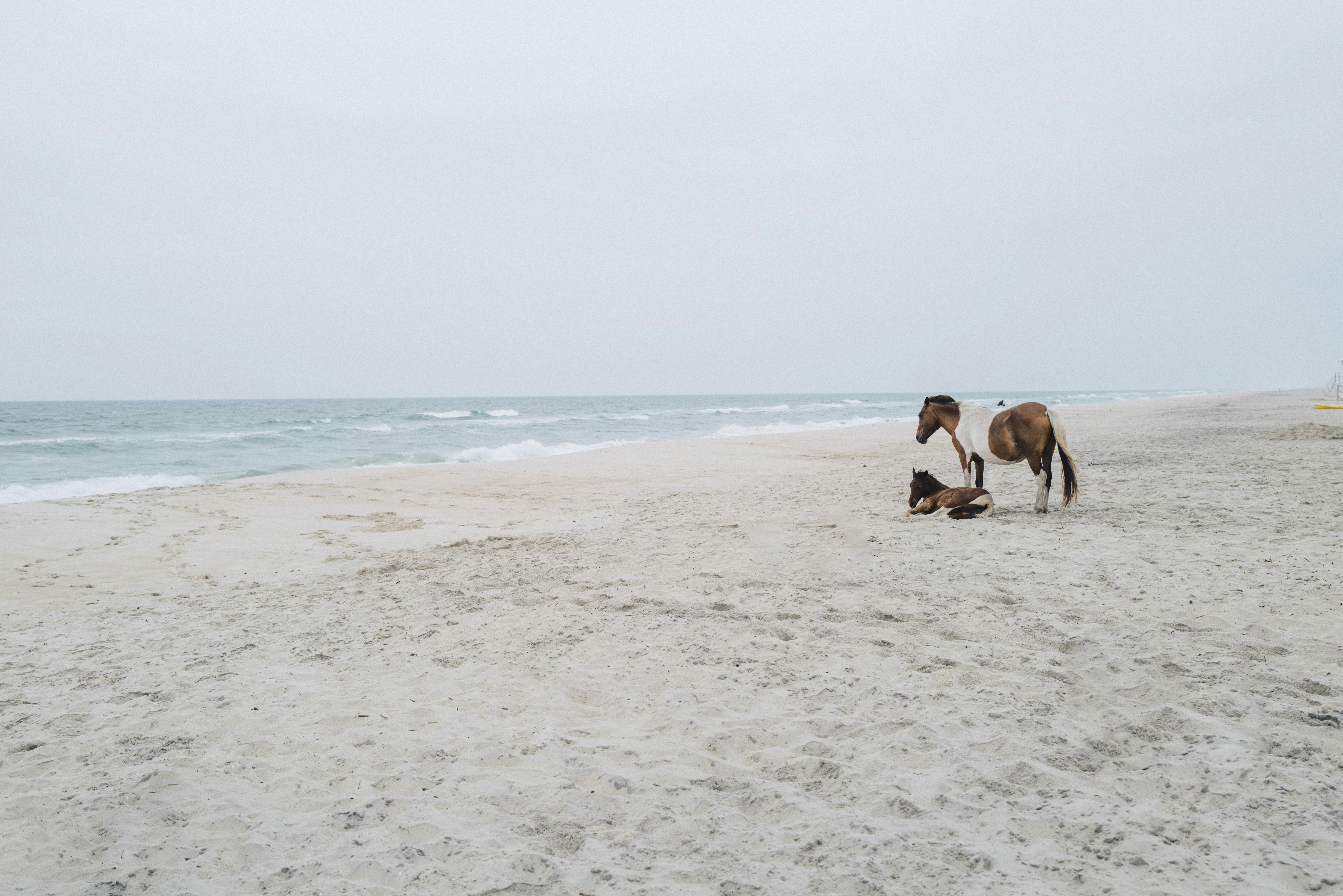 View larger ↗
See the main photograph’s scene caption
Capture date not confirmedAssateague Island National Seashore, Maryland Ocean Beach scenic photograph · Zach Wear · Unsplash License
Resized/cropped for display; original colors retained. Adaptations retain the stated license.
Food, stays & rentals
EXTEND YOUR BEACH DAY
Food & drink nearby
Local dining recommendations
NPS lists seasonal drinks/snacks at the North Beach Beach Hut. Assateague Outfitters also operates Bayside snacks.5 Tides is inside the separate DNR State Park, not an NPS ocean entrance restaurant.
Research notes & location scope
Read this scoped recommendation and location context
Supporting research source ↗ · reviewed 2026-10-26
These listings are unpaid and contain no affiliate links.
Accommodations by the beach
NPS Oceanside/Bayside designated campgrounds provide permitted camping with separate reservations and fees. The Atlantic Hotel at 2 North Main Street in Berlin is mainland lodging reached by road; a room booking includes neither park admission nor beach transport.
Before you book
Confirm the exact property or rental unit, view category, beach route, accessibility and total price directly. Nearby lodging does not establish access to a private beach, a boat transfer or permission to camp.
Research notes & location scope
Read this scoped recommendation and location context
Supporting research source ↗ · Supporting research source ↗ · reviewed 2026-10-26
These listings are unpaid and contain no affiliate links.
Activities & rentals
Assateague Outfitters rents kayaks, canoes, SUPs, bicycles and clam rakes from the end of Bayside Drive inside NPS. It advertises guided wildlife kayak tours and summer 9 am–6 pm service. These are paddling products, not scuba/snorkel trips; do not treat every nearby launch as the meeting point.
Explore nearby beaches
Sources & review date
Guide desk research reviewed 2026-10-26; this is not a field-by-field current verification or an on-site inspection. Official facts, dated agency evidence and editorial assessments retain their own scope. Unknowns and conflicts remain open. Methodology · Rating explanations · Correction history
- Assateague Island National Seashore — Maryland Ocean Beach · identity location ↗
- Assateague Island National Seashore — Maryland Ocean Beach · summary description ↗
- Assateague Island National Seashore — Maryland Ocean Beach · known for ↗
- Assateague Island National Seashore — Maryland Ocean Beach · live weather ↗
- Assateague Island National Seashore — Maryland Ocean Beach · daily forecast ↗
- Assateague Island National Seashore — Maryland Ocean Beach · tides ↗
- Assateague Island National Seashore — Maryland Ocean Beach · surf rip forecast ↗
- Assateague Island National Seashore — Maryland Ocean Beach · official flags closures ↗
- Assateague Island National Seashore — Maryland Ocean Beach · water quality ↗
- Assateague Island National Seashore — Maryland Ocean Beach · public access ↗
- Assateague Island National Seashore — Maryland Ocean Beach · crowds ↗
- Assateague Island National Seashore — Maryland Ocean Beach · sand shoreline ↗
- Assateague Island National Seashore — Maryland Ocean Beach · surf ↗
- Assateague Island National Seashore — Maryland Ocean Beach · shelling ↗
- Assateague Island National Seashore — Maryland Ocean Beach · shark teeth ↗
- Assateague Island National Seashore — Maryland Ocean Beach · sea glass ↗
- Assateague Island National Seashore — Maryland Ocean Beach · driftwood ↗
- Assateague Island National Seashore — Maryland Ocean Beach · snorkeling ↗
- Assateague Island National Seashore — Maryland Ocean Beach · scuba ↗
- Assateague Island National Seashore — Maryland Ocean Beach · wildlife ↗
- Assateague Island National Seashore — Maryland Ocean Beach · accommodations ↗
- Assateague Island National Seashore — Maryland Ocean Beach · commercial activities rentals ↗
- Assateague Island National Seashore — Maryland Ocean Beach · alcohol rules ↗
- Assateague Island National Seashore — Maryland Ocean Beach · fire rules ↗
- Assateague Island National Seashore — Maryland Ocean Beach · camping rules ↗
- Assateague Island National Seashore — Maryland Ocean Beach · shore fishing rules ↗
- Assateague Island National Seashore — Maryland Ocean Beach · hours ↗
- Assateague Island National Seashore — Maryland Ocean Beach · dogs ↗
- Assateague Island National Seashore — Maryland Ocean Beach · lifeguards ↗
- Assateague Island National Seashore — Maryland Ocean Beach · restrooms showers ↗
- Assateague Island National Seashore — Maryland Ocean Beach · parking entry ↗
- Assateague Island National Seashore — Maryland Ocean Beach · accessibility ↗
- Assateague Island National Seashore — Maryland Ocean Beach · driving ↗
- Assateague Island National Seashore — Maryland Ocean Beach · public access rules ↗
- Assateague Island National Seashore — Maryland Ocean Beach · dining ↗
- Assateague Island National Seashore — Maryland Ocean Beach · history ↗
- Assateague Island National Seashore — Maryland Ocean Beach · managing authority ↗
- Assateague Island National Seashore — Maryland Ocean Beach · official source links ↗
- Assateague Island National Seashore — Maryland Ocean Beach · main photo ↗
- Assateague Island National Seashore — Maryland Ocean Beach · photo gallery ↗
- Assateague Island National Seashore — Maryland Ocean Beach · admission payment passes ↗
- Assateague Island National Seashore — Maryland Ocean Beach · plan your visit ↗
- Assateague Island National Seashore — Maryland Ocean Beach · check before you go ↗
- Assateague Island National Seashore — Maryland Ocean Beach · nearby beaches ↗
- Assateague Island National Seashore — Maryland Ocean Beach · closer look ↗
Photo: Assateague Island National Seashore, Maryland Ocean Beach scenic photograph by Zach Wear · Unsplash License. Cropped for display; adaptations retain this license.
Visitor experiences
Original, moderated reviews and photographs. Visit dates and entrances provide context; visitor ratings and reports do not replace official facts or current conditions.
Read approved visitor experiences here when available.