

Calvert County coastal shores · Maryland
Flag Ponds Nature Park Beach
This named shore is in Calvert County, Maryland. Use its named arrival; no city or town boundary is inferred.
Calvert County coastal shores
A Chesapeake Bay nature-park beach reached by a half-mile walk, with fossil hunting, wetlands and woodland trails. Check the seasonal opening days and leave sand one hour before park closure.
Good fit: A managed nature-park beach visit with a half-mile parking-to-sand walk.
Plan around: The beach is about a half-mile walk from parking; entry fees and capacity limits apply. The linked 2020 map shows no guards, rather than establishing current staffing.
- Parking
- Paid entry · capacity limits
Details & sources
Paid entry · capacity limitsDetails & restrictionsFlag Ponds Nature Park Beach · parking entry ↗ - Dogs
- Leashed park access · check sand postings
- Restrooms
- Yes
- Lifeguards
- No
- Key restrictions
- Check before you go
- Best for
- See beach overview
More planning facts: access, driving & fees
- Public access
- Public accessDetails & restrictions
- Beach driving
- Driving permission unconfirmedDetails & restrictions
- Accessibility
- Route endpoints unconfirmedDetails & restrictions
Choose an entrance
Flag Ponds managed parking-to-beach path
See the parking and accessibility evidence below for this named route.
Official route / restriction details ↗Parking, route & accessibility evidence
Parking & entry: Paid entry · capacity limits. Vehicle admission is $5 for everyone November–March; April–October $5 county residents/$20 nonresidents. Bike/walk-in $5/person. Capacity closures may turn arrivals away; sand is a half-mile walk from parking.
Parking source ↗Accessibility: Route endpoints unconfirmed. The reviewed pages do not establish a continuous step-free parking-to-water route, current mat/chair endpoints or remaining sand gap. Confirm the exact required route with the manager before travelling.
Accessibility source ↗Open the county entrance directory ↗
Use the directory to check each entrance’s identity and status. Guide map pins are approximate shoreline locations, not turn-by-turn entrance directions or proof of current opening.
Known for
Miocene fossils and sharks’ teeth along a changing sandy bay shoreline, plus ponds, observation platforms and nature trails.
Rules & facilities
Check before you go
Check the responsible manager’s current notices, arrival terms and any facility or water-quality advisory before departing; confirm any route or amenity essential to your visit.
Admission, payment & passes
Cash or credit card except American Express. Annual pass $30 county residents/$60 nonresidents, plus $10 additional household pass; driver’s license required for pass holders.
What to bring & supporting visit details
Plan your visit
Good fit: beachcombing plus a nature walk. Plan around: half-mile approach, seasonal closed weekdays, vehicle fees and leaving the beach an hour before park closure.
Public or private?
Public · fee applies
Who can visit: Visitors using the documented publicly managed arrival, subject to actual manager notices and admission terms.
Entry route, fees & access boundaries
- Manager / access authority
- Calvert County Department of Parks & Recreation, Natural Resources Division; Flag Ponds 410-586-1477.
- Access basis
- Use the named Flag Ponds Nature Park Beach managed arrival and its posted entry terms. No private community crossing, continuous shoreline entitlement or neighboring park membership is inferred.
- Where to enter
- Use the named Flag Ponds Nature Park Beach managed arrival and its posted entry terms. No private community crossing, continuous shoreline entitlement or neighboring park membership is inferred.
- Fees & reservations
- Cash or credit card except American Express. Annual pass $30 county residents/$60 nonresidents, plus $10 additional household pass; driver’s license required for pass holders.
- Restrictions & exceptions
- Use the mapped public beach-use area and obey the map’s separate Natural Heritage Area restricted-beach-use marking. Seasonal entry/sand closing, capacity controls and any actual construction notices remain separate. The living-shoreline planning page does not establish a whole-beach closure.
- What this label covers
- The named managed beach arrival and its documented visitor areas; no adjoining private crossing, surveyed boundary or current opening is inferred.
Beach ownership, the route across land, public shoreline-use rights and access to facilities are separate questions. Rules vary by state and location. Use the identified public entrance or documented permission; neither a nearby resort nor an admission fee by itself establishes that a beach is private. A mapped beach is not permission to cross private property.
Access policy reviewed 2026-11-04. Not a live closure report or a property-boundary survey.
Allowed & prohibited activities
Alcohol: Alcohol rules are not confirmed for this beach.
What still needs confirmation
The reviewed exact beach operator information does not establish an alcohol permission. Ask directly; an adjacent business serving drinks does not permit drinking on sand.
Fires and grills: Any permitted fire or grill areas still need confirmation. Follow the restrictions stated here.
What still needs confirmation
The reviewed exact beach rules do not establish beach-fire or grill permission. Separate campsite equipment does not authorize a fire on sand.
Overnight camping: Overnight beach camping permission is not confirmed.
What still needs confirmation
The reviewed beach access information does not establish overnight camping permission on this sand. Separately booked lodging or camp areas have their own rules.
Shore fishing: Shore fishing rules are not confirmed for this beach.
What still needs confirmation
No beach-specific shore-casting zone and current restrictions were established. A state fishing license or a nearby pier does not authorize fishing through a bathing area.
- Hours
- Hours & seasonal limits
Fall/winter: Monday and Friday 9–4, weekend 9–5; Tuesday–Thursday closed. Summer Memorial Day through Labor Day: weekdays 9–6, weekends 9–8. Last entry and beach closing are one hour earlier.
Flag Ponds Nature Park Beach · hours ↗ - Dogs on the beach
- Leashed park access · check sand postings
The Natural Resources rules allow leashed dogs except at Battle Creek Cypress Swamp; this does not establish off-leash or dog-swimming permission. Check exact sand/water postings.
Flag Ponds Nature Park Beach · dogs ↗ - Lifeguards
- No guards on linked 2020 map
The park’s currently linked official August 2020 trail map labels the beach “No lifeguards are on duty.” Do not plan on lifeguard coverage; recheck staff for any subsequent program change.
Flag Ponds Nature Park Beach · lifeguards ↗ - Restrooms
- Restrooms · outdoor shower
The current park page lists restroom facilities and an outdoor shower. Exact seasonal fixture operation and accessible route endpoints remain separate clarification questions.
Flag Ponds Nature Park Beach · restrooms showers ↗ - Access & beach rules
- Rules & restrictions
Use the mapped public beach-use area and obey the map’s separate Natural Heritage Area restricted-beach-use marking. Seasonal entry/sand closing, capacity controls and any actual construction notices remain separate. The living-shoreline planning page does not establish a whole-beach closure.
Flag Ponds Nature Park Beach · public access rules ↗ - Beach driving
- Driving permission unconfirmed
The reviewed manager information does not establish recreational vehicle access onto the beach; use the designated landward arrival and confirm any mobility accommodation separately.
Flag Ponds Nature Park Beach · driving ↗
Conditions & activities Surf, sand, wildlife and suitability
Conditions at the beach
Local times use Eastern Time. No beach observation or saved forecast is displayed here. Forecast issue times, observation times, tide prediction dates and laboratory sample dates remain separate from desk-research dates. A linked source does not confirm current opening, a warning flag or swimming safety.
Weather observation
No exact on-beach weather observation or observation station is assigned here. The linked National Weather Service page provides forecast navigation; a forecast is a prediction, not an observed beach condition.
Daily forecast
The independently checked National Weather Service point-forecast link is available for this approximate planning point. The returned source is a regional marine grid, with no county land zone assigned at this point. It is not a forecast of breaking surf at this beach. No saved numeric forecast is displayed here. Forecast issue and prediction times are separate from source review and are not on-beach observations.
High & low tides
NOAA station 8577004 Long Beach is a regional Calvert Chesapeake Bay tide reference. Prediction times are not observations, exact beach water depth or guaranteed access; retain station location and Eastern daylight/standard time separately.
Surf & rip forecast
No exact named-beach surf or rip-current observation/feed was established. Regional NWS forecasts must retain their grid/marine scope; no Atlantic surf forecast or neighboring reading is substituted.
Closures & warning flags
Check the exact manager’s posted notices before departure. No dated observed flag feed for this beach was established; agency opening hours and historical bacteria status are different from current flags.
Water quality
Calvert public bathing-beach sampling normally runs Memorial Day through Labor Day. Review the actual named health-map station, sample date and advisory/retrieval times; no historical result or absence of a displayed marker establishes current safety at this entrance.
National Weather Service point forecast ↗ for the independently reviewed approximate planning point.
Crowd meter
No repeatable beach-specific crowd measure was established; no crowd score is assigned. Follow capacity notices and any admission restrictions rather than assuming space.
Sand & sandcastles
A sandy Chesapeake Bay beach; tides and storms can change exposed sand and shoreline geometry. A planning pin does not establish property limits.
Surfing profile
This is Chesapeake Bay rather than an Atlantic ocean surf beach. No reliable named surfing-break assessment was established; surf suitability remains Unrated.
Beachcombing
Park shoreline beachcombing may reveal sharks’ teeth and other Miocene fossils. Keep to open trails and shore; collection expectations are possible finds, not guaranteed discoveries.
Park shoreline beachcombing may reveal sharks’ teeth and other Miocene fossils. Keep to open trails and shore; collection expectations are possible finds, not guaranteed discoveries.
Snorkeling & scuba diving
No documented exact shore-snorkeling route was established from the manager/operator, county water-activities search and local dive operator review. Shore snorkeling remains Unrated; swimming or paddling is not proof of snorkeling suitability.
No exact recreational beach-entry dive route or matched local offshore itinerary was established. Scuba remains Unrated; the separately located Solomons shop is not proof of a dive from this beach.
Clothing-optional, nudity & topless sunbathing
No official clothing-optional designation or full-nudity permission was established for this exact beach. It is excluded from verified permissive filter matches pending scoped authority evidence.
A separate current ruling for female-topless sunbathing at this exact beach was not established. Do not treat silence, general swimwear wording or a full-nudity rule as verified topless permission.
Shore & sky wildlife
The park contains sandy beach, freshwater ponds, forest and wildlife displays; use its observation platforms for habitat watching. No species examples are borrowed from Calvert Cliffs or another county.
History & interesting facts
Flag Ponds served a pound-net fishery from the early 1900 s to 1955. The remaining Buoy Hotel shanty was destroyed in 2012 and reconstructed in 2015 as an interpretive exhibit.
Water clarity & shore snorkeling
Typical clarity: Not yet assessed. Typical underwater clarity has not been assessed for this named shore. Water color, laboratory samples and forecasts do not measure visibility.
Shore snorkeling not yet assessed. No documented exact shore-snorkeling route was established from the manager/operator, county water-activities search and local dive operator review. Shore snorkeling remains Unrated; swimming or paddling is not proof of snorkeling suitability.
Typical clarity describes how easily you may see through the water. It does not establish bacterial water quality, safe swimming, calm conditions or visibility today.
Evidence, location scope & review
Desk review 2026-11-04 · Flag Ponds Nature Park Beach. This is not an on-site inspection or a current conditions report.
Flag Ponds Nature Park Beach
Flag Ponds Nature Park | Calvert County, MD - Official Website ↗
Find clear-water and shore-snorkeling options ↗ · Report a change ↗
A closer look
Photos of this beach and its surroundings. Select a photo to view it larger. These are recorded views, not live conditions.
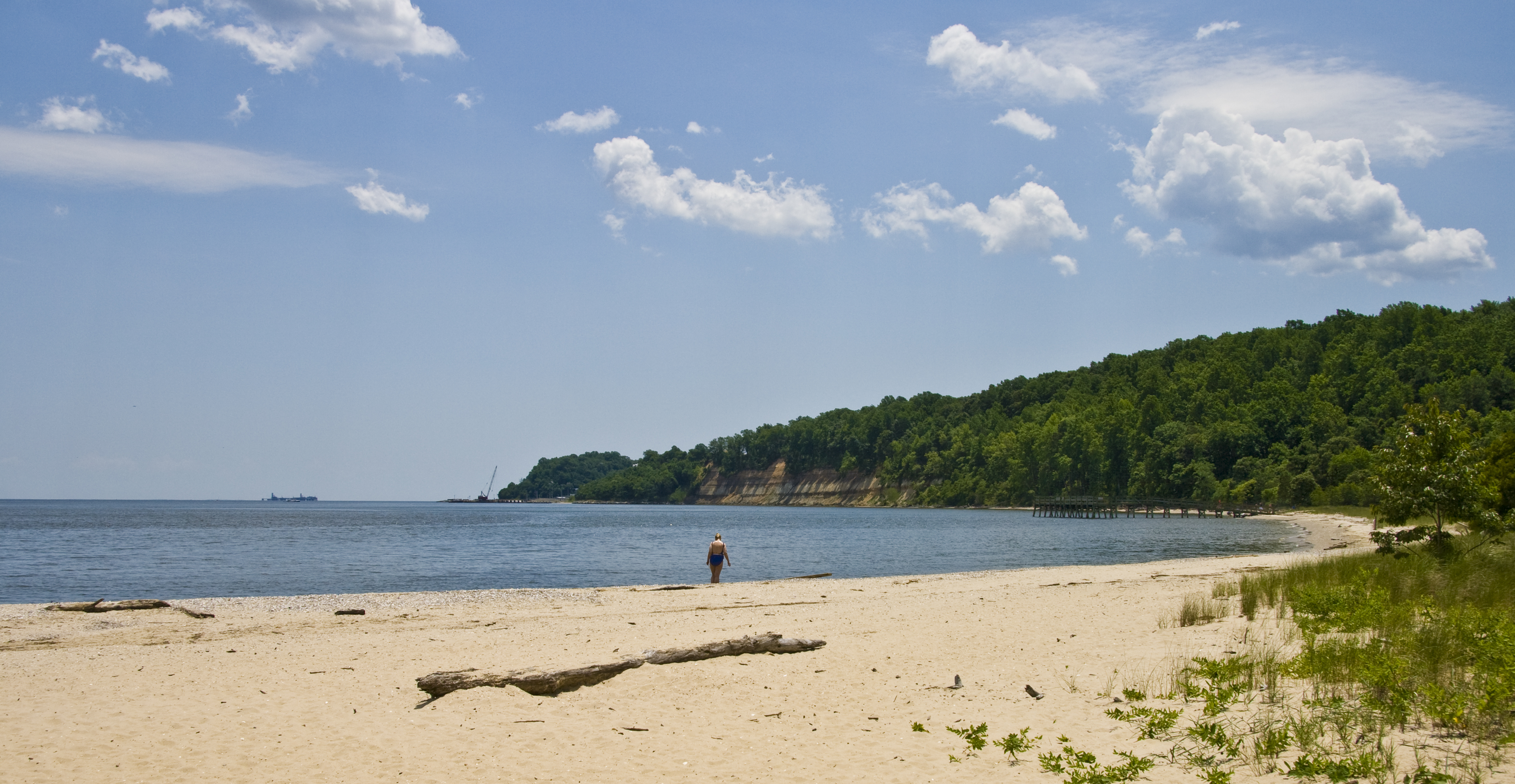 View larger ↗
See the main photograph’s scene caption
Taken: 2009-06-30Flag Ponds Park · Acroterion · CC BY-SA 4.0
Resized/cropped for display; original colors retained. Adaptations retain the stated license.
Food, stays & rentals
EXTEND YOUR BEACH DAY
Food & drink nearby
Local dining recommendations
restaurant
The Tavern
Confirm current arrangements directly.
Separate town dining; official county listing, no exact walk distance or delivery implied.
Visit The Tavern website ↗Website & source check
Website checked ↗ · checked 2026-11-04 (Eastern Time). Official primary operator or county-tourism source checked; confirm current availability and departure directly.
Research notes & location scope
The Tavern at 4975 St. Leonard Road is a separate St. Leonard pub/restaurant; Solomons has separately located dining options. No on-sand concession or delivery is implied.
Supporting research source ↗ · reviewed 2026-11-04
These listings are unpaid and contain no affiliate links.
Accommodations by the beach
hotel
Hilton Garden Inn Solomons
Confirm current arrangements directly.
Separate southern-Calvert hotel, not beachfront at the named guide; arrange transport.
Visit Hilton Garden Inn Solomons website ↗Website & source check
Website checked ↗ · checked 2026-11-04 (Eastern Time). Official primary operator or county-tourism source checked; confirm current availability and departure directly.
Before you book
Confirm the exact property or rental unit, view category, beach route, accessibility and total price directly. Nearby lodging does not establish access to a private beach, a boat transfer or permission to camp.
Research notes & location scope
Hilton Garden Inn Solomons at 13100 Dowell Road is a separately located southern-Calvert hotel; it is not beachfront at this beach and no included entry or shuttle is implied.
Supporting research source ↗ · reviewed 2026-11-04
These listings are unpaid and contain no affiliate links.
Activities & rentals
The exact beach manager/operator pages did not establish an on-beach equipment-delivery or water-tour service. Separately listed county operators require their own booking, departure and equipment confirmation.
Explore nearby beaches
Review dates & updates
These are desk-research dates for each named category, including unresolved facts. They are not on-site inspections, current-opening confirmations or water-safety observations.
- identity location: research reviewed 2026-11-04 · verified
- summary description: research reviewed 2026-11-04 · verified
- known for: research reviewed 2026-11-04 · verified
- live weather: research reviewed 2026-11-04 · verified
- daily forecast: research reviewed 2026-11-04 · verified
- tides: research reviewed 2026-11-04 · verified
- surf rip forecast: research reviewed 2026-11-04 · unresolved
- official flags closures: research reviewed 2026-11-04 · unresolved
- water quality: research reviewed 2026-11-04 · unresolved
- public access: research reviewed 2026-11-04 · verified
- crowds: research reviewed 2026-11-04 · unresolved
- sand shoreline: research reviewed 2026-11-04 · verified
- surf: research reviewed 2026-11-04 · unresolved
- shelling: research reviewed 2026-11-04 · verified
- shark teeth: research reviewed 2026-11-04 · verified
- sea glass: research reviewed 2026-11-04 · unresolved
- driftwood: research reviewed 2026-11-04 · unresolved
- snorkeling: research reviewed 2026-11-04 · unresolved
- scuba: research reviewed 2026-11-04 · unresolved
- wildlife: research reviewed 2026-11-04 · verified
- accommodations: research reviewed 2026-11-04 · verified
- commercial activities rentals: research reviewed 2026-11-04 · unresolved
- alcohol rules: research reviewed 2026-11-04 · unresolved
- fire rules: research reviewed 2026-11-04 · unresolved
- camping rules: research reviewed 2026-11-04 · unresolved
- shore fishing rules: research reviewed 2026-11-04 · unresolved
- hours: research reviewed 2026-11-04 · verified
- dogs: research reviewed 2026-11-04 · verified
- lifeguards: research reviewed 2026-11-04 · verified
- restrooms showers: research reviewed 2026-11-04 · verified
- parking entry: research reviewed 2026-11-04 · verified
- accessibility: research reviewed 2026-11-04 · unresolved
- driving: research reviewed 2026-11-04 · unresolved
- public access rules: research reviewed 2026-11-04 · verified
- dining: research reviewed 2026-11-04 · verified
- history: research reviewed 2026-11-04 · verified
- managing authority: research reviewed 2026-11-04 · verified
- official source links: research reviewed 2026-11-04 · verified
- main photo: research reviewed 2026-11-04 · verified
- photo gallery: research reviewed 2026-11-04 · verified
- admission payment passes: research reviewed 2026-11-04 · verified
- plan your visit: research reviewed 2026-11-04 · verified
- check before you go: research reviewed 2026-11-04 · verified
- nearby beaches: research reviewed 2026-11-04 · verified
- closer look: research reviewed 2026-11-04 · unresolved
Sources & review date
Guide desk research reviewed 2026-11-04; this is not a field-by-field current verification or an on-site inspection. Official facts, dated agency evidence and editorial assessments retain their own scope. Unknowns and conflicts remain open. Methodology · Rating explanations · Correction history
- Flag Ponds Nature Park Beach · identity location ↗
- Flag Ponds Nature Park Beach · summary description ↗
- Flag Ponds Nature Park Beach · known for ↗
- Flag Ponds Nature Park Beach · live weather ↗
- Flag Ponds Nature Park Beach · daily forecast ↗
- Flag Ponds Nature Park Beach · tides ↗
- Flag Ponds Nature Park Beach · surf rip forecast ↗
- Flag Ponds Nature Park Beach · official flags closures ↗
- Flag Ponds Nature Park Beach · water quality ↗
- Flag Ponds Nature Park Beach · public access ↗
- Flag Ponds Nature Park Beach · crowds ↗
- Flag Ponds Nature Park Beach · sand shoreline ↗
- Flag Ponds Nature Park Beach · surf ↗
- Flag Ponds Nature Park Beach · shelling ↗
- Flag Ponds Nature Park Beach · shark teeth ↗
- Flag Ponds Nature Park Beach · sea glass ↗
- Flag Ponds Nature Park Beach · driftwood ↗
- Flag Ponds Nature Park Beach · snorkeling ↗
- Flag Ponds Nature Park Beach · scuba ↗
- Flag Ponds Nature Park Beach · wildlife ↗
- Flag Ponds Nature Park Beach · accommodations ↗
- Flag Ponds Nature Park Beach · commercial activities rentals ↗
- Flag Ponds Nature Park Beach · alcohol rules ↗
- Flag Ponds Nature Park Beach · fire rules ↗
- Flag Ponds Nature Park Beach · camping rules ↗
- Flag Ponds Nature Park Beach · shore fishing rules ↗
- Flag Ponds Nature Park Beach · hours ↗
- Flag Ponds Nature Park Beach · dogs ↗
- Flag Ponds Nature Park Beach · lifeguards ↗
- Flag Ponds Nature Park Beach · restrooms showers ↗
- Flag Ponds Nature Park Beach · parking entry ↗
- Flag Ponds Nature Park Beach · accessibility ↗
- Flag Ponds Nature Park Beach · driving ↗
- Flag Ponds Nature Park Beach · public access rules ↗
- Flag Ponds Nature Park Beach · dining ↗
- Flag Ponds Nature Park Beach · history ↗
- Flag Ponds Nature Park Beach · managing authority ↗
- Flag Ponds Nature Park Beach · official source links ↗
- Flag Ponds Nature Park Beach · main photo ↗
- Flag Ponds Nature Park Beach · photo gallery ↗
- Flag Ponds Nature Park Beach · admission payment passes ↗
- Flag Ponds Nature Park Beach · plan your visit ↗
- Flag Ponds Nature Park Beach · check before you go ↗
- Flag Ponds Nature Park Beach · nearby beaches ↗
- Flag Ponds Nature Park Beach · closer look ↗
Photo: Flag Ponds Park by Acroterion · CC BY-SA 4.0. Cropped for display; adaptations retain this license.

Visitor experiences
Original, moderated reviews and photographs. Visit dates and entrances provide context; visitor ratings and reports do not replace official facts or current conditions.
Read approved visitor experiences here when available.