
Wakulla County Gulf Coast · Florida
Mashes Sands Beach
- State
- Florida
- County
- Wakulla County
- City / community
- Panacea
Florida Big Bend · Wakulla County Gulf Coast
A natural bay-edge beach beside salt marsh, with a mobile toilet and a reported beach-access mat. The nearby fishing pier is under reconstruction and closed.
Good fit: A natural bay-edge beach beside salt marsh, with a mobile toilet and a reported beach-access mat. The nearby fishing pier is under reconstruction and closed.
Plan around: Fishing pier closed during reconstruction. Reported mat deployment, beach-only fees and guard/dog rules require confirmation.
PLAN THE BASICS
At a glance
- Dogs
- Unknown · clarification pendingDetails & restrictions
- Restrooms
- YesDetails & restrictions
- Lifeguards
- Unknown · clarification pendingDetails & restrictions
- Public access
- Public accessDetails & restrictions
- Beach driving
- NoDetails & restrictions
Choose an entrance
Mashes Sands Beach at 901 Mashes Sands Road
Named county beach at 901 Mashes Sands Road; pier under reconstruction and 801 boat ramp are separate arrivals
Official route / restriction details ↗Parking, route & accessibility evidence
Parking & entry: Use the beach address and signed parking. The 2024 county schedule lists separate pavilion and launch charges; it does not establish a current general beach parking fee. Do not transfer a vehicle/trailer launch fee to a beach-only visit.
Parking source ↗Accessibility: The county tourism authority reports a beach-access mat to the waterline. Tide, deployment and remaining soft-sand gaps need confirmation; a mat is not proof of a continuous accessible route to swimming. The beach has a mobile restroom, not a confirmed accessible restroom.
Accessibility source ↗Open the county entrance directory ↗
Use the directory to check each entrance’s identity and status. Guide map pins are approximate shoreline locations, not turn-by-turn entrance directions or proof of current opening.
Known for
Salt-marsh scenery, shorebirds and a tidal bay beach; the fishing pier is currently closed.
Sources & review dates
known for
Source ↗ · Additional source ↗ · reviewed 2026-10-05
Fishing pier closed during reconstruction. Reported mat deployment, beach-only fees and guard/dog rules require confirmation.
Rules & facilities
Check before you go
Confirm the mat’s deployment and beach-only fees; the county says the fishing pier is still under reconstruction and closed. Check current DOH exact-site water notices.
Sources & review dates
check before you go
Source ↗ · Additional source ↗ · reviewed 2026-10-05
Admission, payment & passes
The August 2024 county schedule separates launch charges and reservable pavilions. Confirm beach-only entry and parking charges; a boat-launch fee is not automatically a sand-visit charge.
Sources & review dates
admission payment passes
Source ↗ · Additional source ↗ · reviewed 2026-10-05
What to bring & supporting visit details
Plan your visit
Plan a tidal coastal outing with drinking water and food arranged separately. Confirm exact dog, lifeguard and route fixtures; pavilions are picnic shelters, not shade along the whole sand.
Sources & review dates
plan your visit
Source ↗ · reviewed 2026-10-05
Public or private?
Public access
Who can visit: Open to the general public, including visitors, during permitted hours and subject to posted rules.
Entry route, fees & access boundaries
- Manager / access authority
- Wakulla County Parks and Facilities manages this county beach. County boat-launch and pavilion operations are separate facility scopes.
- Access basis
- This listing covers a publicly managed beach access or park, not a private guest-only beach.
- Where to enter
- Use the county’s named public beach arrival, distinguishing it from the separately managed or charged boat-launch facilities.
- Fees & reservations
- The August 2024 county schedule separates launch charges and reservable pavilions. Confirm beach-only entry and parking charges; a boat-launch fee is not automatically a sand-visit charge.
- Restrictions & exceptions
- Use the named beach arrival. Respect pier reconstruction barriers; the separate boat ramp and pavilion reservations have their own fees and rules.
- What this label covers
- Named shoreline and supported arrival only; public access is separate from temporary closure.
Beach ownership, the route across land, public shoreline-use rights and access to facilities are separate questions. Rules vary by state and location. Use the identified public entrance or documented permission; neither a nearby resort nor an admission fee by itself establishes that a beach is private. A mapped beach is not permission to cross private property.
Access policy reviewed 2026-10-05. Not a live closure report or a property-boundary survey.
Allowed & prohibited activities
Alcohol: Alcohol rules are not confirmed for this beach.
What still needs confirmation
Exact alcohol rules for this shoreline were not established. A county pavilion rental agreement is not a blanket beach rule, and rules for a different refuge unit are not transferred here.
Fires and grills: Any permitted fire or grill areas still need confirmation. Follow the restrictions stated here.
What still needs confirmation
No exact beach fire or designated grill permission was verified. A picnic shelter is not a fire permit; confirm the specific fixture and rule before lighting anything.
Overnight camping: Overnight beach camping permission is not confirmed.
What still needs confirmation
Beach hours do not establish overnight camping permission. No designated campsite or beach overnight authorization was confirmed at this exact county beach.
Shore fishing: The county identifies fishing opportunities but says the pier is closed during reconstruction. Do not fish from the closed pier; verify the permitted shore position and marked water-use restrictions.
Sources & review dates
Alcohol
Source ↗ · Additional source ↗ · reviewed 2026-10-05
Fires and grills · Overnight camping
Source ↗ · reviewed 2026-10-05
Shore fishing
Source ↗ · Additional source ↗ · reviewed 2026-10-05
- Hours
- County beach hours: 6 a.m. to midnight. This does not reopen a closed pier or establish overnight camping.Mashes Sands Beach · hours evidence ↗
- Dogs on the beach
- Current exact sand dog rules require county confirmation. BringFido’s nearby Ochlockonee Bay listing describes a boat-ramp location, not permission for Mashes Sands beach or Shell Point sand.Mashes Sands Beach · dogs evidence ↗
- Lifeguards
- No current entrance-specific lifeguard season, tower schedule or staffed program was established. A beach or swim listing does not establish supervision.Mashes Sands Beach · lifeguards evidence ↗
- Restrooms
- The county lists a mobile restroom at the beach. No current shower or rinse station was verified; boat-ramp fixtures are separate.Mashes Sands Beach · restrooms showers evidence ↗
- Access & beach rules
- Use the named beach arrival. Respect pier reconstruction barriers; the separate boat ramp and pavilion reservations have their own fees and rules.Mashes Sands Beach · public access rules evidence ↗
- Beach driving
- Arrive by lawful roads and signed parking. Road and launch access do not establish permission to drive on beach sand or tidal flats.Mashes Sands Beach · driving evidence ↗
Conditions & activities Surf, sand, wildlife and suitability
Conditions at the beach
Saved reports below are dated snapshots, not live conditions. JavaScript refreshes them from official sources when available. Source timestamps and tide times identify their time zone.
Weather observation
No usable dated snapshot available. Follow the official source link for updated information.
UV forecast
No current-hour UV estimate is shown in this saved page. Use sun protection; the live forecast loads when available.
Daily forecast
Saved report · not live. This dated snapshot may be out of date. Check the official source before your visit.
Saved forecast for this beach’s NWS grid
- 2026-10-05T17:00:00-04:00–2026-10-05T18:00:00-04:00: This Afternoon · 81°F · Showers And Thunderstorms · wind 5 mph ESE
- 2026-10-05T18:00:00-04:00–2026-10-06T06:00:00-04:00: Tonight · 67°F · Showers And Thunderstorms · wind 5 to 10 mph E
Source issued/updated: 2026-10-05T20:52:03+00:00.
Retrieved: 2026-10-05T21:10:12.169Z.
Live-use expiration: 2026-10-05T22:00:00.000Z. This static copy never certifies current conditions.
High & low tides
Saved prediction · not live. This dated snapshot may be out of date. Check the official source before your visit.
St. Marks River Entrance. NOAA St. Marks River Entrance prediction reference about 19.5 km straight-line away; regional predictions, not local observation, route depth, navigation or swimming safety. Predictions, not measured water levels or safe crossing times.
- 2026-10-05 03:40 · Low tide
- 2026-10-05 09:48 · High tide
- 2026-10-05 17:30 · Low tide
- 2026-10-06 00:04 · High tide
- 2026-10-06 05:18 · Low tide
- 2026-10-06 11:31 · High tide
- 2026-10-06 18:25 · Low tide
Prediction dates: 2026-10-05–2026-10-06 · station local time.
Retrieved: 2026-10-05T21:10:11.827Z.
Live-use expiration: 2026-10-06T21:10:11.827Z. This static copy never certifies current conditions.
St. Marks River Entrance. NOAA St. Marks River Entrance prediction reference about 19.5 km straight-line away; regional predictions, not local observation, route depth, navigation or swimming safety. Predictions, not measured water levels or safe crossing times.
NOAA tide station ↗NOAA swim & rip-current forecast
No usable dated snapshot available. Follow the official source link for updated information.
Forecast risk is not the flag flying at this beach. Conditions can vary within the forecast area.
Official local flag & condition status
Flag color: not currently verified
Check the named beach, posted restrictions and storm-repair notices. No dated observed flag feed is connected. Forecasts do not establish swimming safety or current opening.
The Beach Database does not convert weather or a rip-current forecast into a colored flag. Check flags and signs on arrival and ask a lifeguard where available.
Weather warnings & alerts
Saved report · not live. This dated snapshot may be out of date. Check the official source before your visit.
Alerts returned at the recorded check
- Flood Watch · Flood Watch issued October 5 at 3:39PM EDT until October 5 at 8:00PM EDT by NWS Tallahassee FL · source expiration 2026-10-05T20:00:00-04:00
Source issued/updated: 2026-10-05T21:09:33+00:00.
Retrieved: 2026-10-05T21:10:11.910Z.
Live-use expiration: 2026-10-05T23:09:33.000Z. This static copy never certifies current conditions.
Weather alerts do not confirm swimming safety, lifeguard staffing, water quality or beach closures. No alert does not mean safe water.
Water quality
Wakulla Health monitors Shell Point and Mash Island beach waters. Use the current exact-site notice and dated result, not a nearby beach result or an undated good-water claim.
Sources & review dates
water quality
Source ↗ · Additional source ↗ · reviewed 2026-10-05
Crowd meter
Editorial fit: a nature-oriented salt-marsh beach. No measured crowd or parking-occupancy forecast is available.
Sources & review dates
crowds
Source ↗ · Additional source ↗ · reviewed 2026-10-05
Sand & sandcastles
A sandy bay-edge shore bordered by salt marsh, shaped by tide and erosion rather than a broad ocean strand.
Sources & review dates
sand shoreline
Source ↗ · Additional source ↗ · reviewed 2026-10-05
Surfing profile
No verified wave-surfing break or consistent surf rating was established for this sheltered bay shore.
Sources & review dates
surf
Source ↗ · reviewed 2026-10-05
Beachcombing
Shells may occur on this tidal shore, but no exact collection rules, abundance rating or reliably productive shelling route was confirmed.
No documented productive shark-tooth area or reliable find rate was established for this exact shore. Do not plan a fossil hunt on a promise of finds.
Sources & review dates
shelling · shark teeth
Source ↗ · Additional source ↗ · reviewed 2026-10-05
Snorkeling & scuba diving
No tested visibility, verified snorkeling route or exact permitted snorkeling zone was established. Tidal bay water and shallow appearance do not establish a safe or clear-water outing.
No named shore-entry scuba site, tested visibility or exact operating dive service for this beach was confirmed. Inland spring/cave diving listings do not establish a coastal dive here.
Sources & review dates
snorkeling
Source ↗ · Additional source ↗ · reviewed 2026-10-05
scuba
Source ↗ · Additional source ↗ · reviewed 2026-10-05
Shore & sky wildlife
The county describes native coastal wildlife and salt-marsh habitat. Shorebirds and tidal wildlife are part of the setting; do not disturb feeding or nesting areas.
Sources & review dates
wildlife
Source ↗ · Additional source ↗ · reviewed 2026-10-05
History & interesting facts
DEP’s August 2024 erosion report identifies a critically eroded segment around Mashes Sands. This is a dated coastal-management designation, not an assertion that today’s beach is closed.
Sources & review dates
history
Source ↗ · reviewed 2026-10-05
A closer look
Photos of this beach and its surroundings. Select a photo to view it larger. These are recorded views, not live conditions.
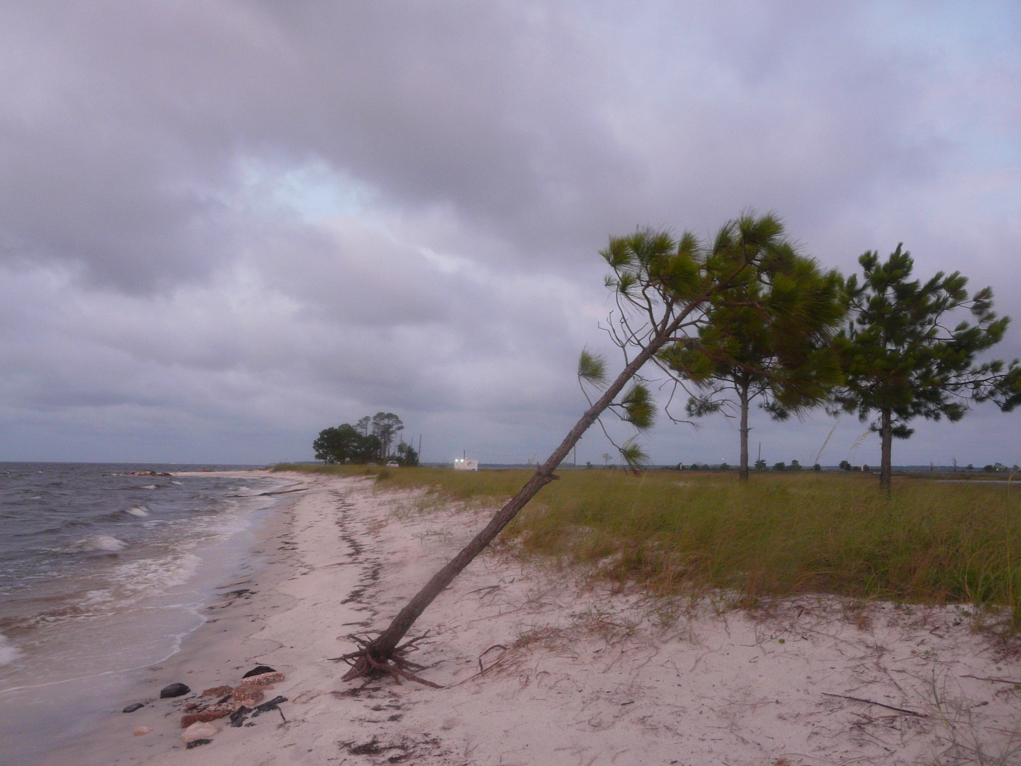 View larger ↗
Mashes Sands Beach · The Bushranger · CC BY-SA 4.0 · captured 2022-06-17; archival photograph, not current access or conditions.
Taken: 2022-06-17Mashes Sands leaning tree on beach · The Bushranger · CC BY-SA 4.0
Resized/cropped for display; original colors retained. Adaptations retain the stated license.
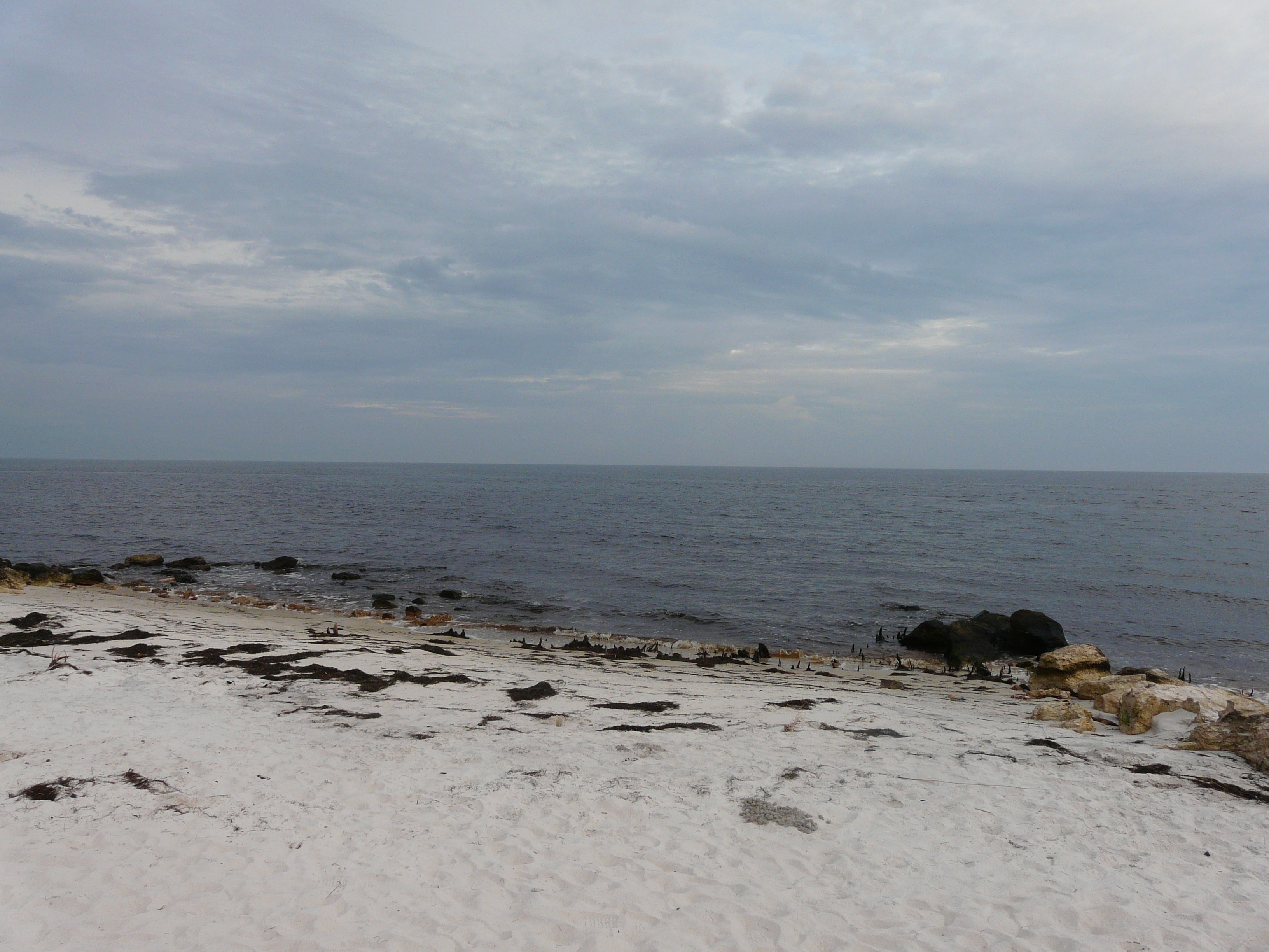 View larger ↗
Mashes Sands Beach · The Bushranger · CC BY-SA 4.0 · captured 2020-10-08; archival photograph, not current access or conditions.
Taken: 2020-10-08Mashes Sands beach October 8 2020 · The Bushranger · CC BY-SA 4.0
Resized/cropped for display; original colors retained. Adaptations retain the stated license.
Food, stays & rentals
EXTEND YOUR BEACH DAY
Food & drink nearby
Local dining recommendations
Local dining recommendations: Angelo & Sons in Panacea is a separate waterfront seafood stop identified by county tourism. Seinyard at Wildwood in Crawfordville is another drive-away option. Confirm service before setting out; neither is represented as a walkable concession at this entrance.
Sources & review dates
dining
Source ↗ · reviewed 2026-10-05
Accommodations by the beach
Sweet Magnolia Inn lists six suites at 803 Port Leon Drive in St. Marks and describes an adults-only stay. It is a separate road-transfer option, not lodging on this beach. Shell Island Fish Camp offers booked lodging/RV stays in St. Marks; check availability and the specific accommodation before travel.
Sources & review dates
accommodations
Source ↗ · Additional source ↗ · Additional source ↗ · reviewed 2026-10-05
Activities & rentals
St. Marks Outfitters offers booked inshore fishing and guided kayak/eco outings from St. Marks. Shell Island Fish Camp lists boat rentals and fishing trips. Confirm the actual launch and itinerary; neither listing establishes a beach-side concession or permission to launch anywhere.
Sources & review dates
commercial activities rentals
Source ↗ · Additional source ↗ · Additional source ↗ · reviewed 2026-10-05
Explore nearby beaches
Sources & review date
Guide desk research reviewed 2026-10-05; this is not a field-by-field current verification or an on-site inspection. Official facts, dated agency evidence and editorial assessments retain their own scope. Unknowns and conflicts remain open. Methodology · Rating explanations · Correction history
- Mashes Sands Beach managing authority ↗
- Mashes Sands Beach · hours evidence ↗
- Mashes Sands Beach · dogs evidence ↗
- Mashes Sands Beach · lifeguards evidence ↗
- Mashes Sands Beach · restrooms showers evidence ↗
- Mashes Sands Beach · public access rules evidence ↗
- Mashes Sands Beach · driving evidence ↗
- Mashes Sands Beach · parking entry evidence ↗
- Mashes Sands Beach · accessibility evidence ↗
- Mashes Sands Beach · sand shoreline evidence ↗
- Mashes Sands Beach · surf evidence ↗
- Mashes Sands Beach · water quality evidence ↗
Photo: Mashes Sands leaning tree on beach by The Bushranger · CC BY-SA 4.0. Cropped for display; adaptations retain this license.

Visitor experiences
Original, moderated reviews and photographs. Visit dates and entrances provide context; visitor ratings and reports do not replace official facts or current conditions.
Read approved visitor experiences here when available.