
Talbot Islands & Mayport · Florida
Boneyard Beach
- State
- Florida
- County
- Duval County
- City / community
- Jacksonville
Northeast Florida · Talbot Islands & Mayport
Explore the shoreline at Big Talbot Island, a natural preserve known for bird-watching and photography. Plan a nature walk and a picnic among the fallen trees.
Good fit: Fallen trees, coastal habitat and a beach made for exploring.
Plan around: Choose your entrance before setting off: facilities and restrictions vary along the shoreline.
- Parking
- $3 per vehicle
Details & sources
- Dogs
- No
Details & sources
No pets on the beach
Leashed dogs are permitted on designated trails and picnic areas, not the beach.
Florida State Parks · Big Talbot amenities ↗ - Restrooms
- Yes
Details & sources
Bluffs and boat-ramp facilities
Restrooms are at the Bluffs picnic area and boat-ramp parking area, not on the shoreline. The park lists accessible restrooms; no separate opening schedule is published.
Florida State Parks · Big Talbot amenities ↗ - Lifeguards
- No
Details & sources
No lifeguards
The park explicitly lists no lifeguard coverage and advises against swimming in Nassau Sound.
Florida State Parks · Big Talbot amenities ↗ - Key restrictions
- Check before you go
Details & sources
Use designated trails; do not climb across fragile bluffs or collect driftwood. Pets are not permitted on the beach or boardwalks. State park service-animal provisions apply.
Florida State Parks · Big Talbot amenities ↗ - Best for
- See beach overview
More planning facts: access, driving & fees
- Public access
- Public accessDetails & restrictions
- Beach driving
- NoDetails & restrictions
- Accessibility
- Accessible overlook; beach route differsDetails & restrictions
- Entry fee
- $3 per vehicle.Details & restrictions
Choose an entrance
$3 per vehicle. Check the route and parking details below, then choose an entrance in the county directory.
Parking, route & accessibility evidence
Parking & entry: $3 per vehicle. Use Big Talbot Island’s Bluffs picnic-area parking for the shoreline visit. Up to eight people per vehicle. The state park lists one $3 payment covering all four Big Talbot parking areas for the day; scan the official on-site QR code to pay. Day use: 8 a.m.–sunset; the boat ramp’s 24-hour opening does not extend beach hours.
Parking source ↗Accessibility: Accessible overlook; beach route differs. A Mobi-Mat serves the elevated Bluffs viewing platform. The Shoreline Trail starts at the north end of the Bluffs lot. The park does not confirm a continuous wheelchair-accessible route onto Boneyard Beach; call 904-251-2320.
Accessibility source ↗Open the county entrance directory ↗
Use the directory to check each entrance’s identity and status. Guide map pins are approximate shoreline locations, not turn-by-turn entrance directions or proof of current opening.
WHY THIS BEACH STANDS OUT
Known for
Signature scenery
Standout driftwood landscape
Weathered trunks and fallen trees define this protected shoreline. It is exceptional for viewing and photography; driftwood collection is prohibited.
Shown only for unusually strong ratings or a distinctive, well-documented feature. Live conditions, rules and availability can change.
Florida State Parks does not recommend swimming here because of strong currents and marine wildlife in Nassau Sound. Plan a shoreline walk instead.
Rules & facilities
Check before you go
Swimming flag: no dated location-specific official flag report is connected for this guide. Do not infer a flag from the regional rip-current forecast; verify flags and signs on arrival.
Closures and access: check Duval beach safety notifications for the named access, managing park or city. A countywide notice is not automatically beach-specific.
Water quality: the nearest same-county Florida Healthy Beaches station, distance disclosure and dated sample appear in Conditions & activities as dated saved results and refresh from the verified snapshot when available. A nearby station is context, not a sample taken at this beach.
Forecast context: the NWS surf-zone forecast and NOAA tide prediction in that section are regional planning tools, not current water measurements or permission to enter.
Browse all 106 Duval County public beach accesses ↗
Admission, payment & passes
Day-use admission
$3 per vehicle. The fee covers all four Big Talbot parking areas for that day. Limit eight people per vehicle.
Official fee page ↗ · Buy a day pass online ↗Accepted payment
The park directs visitors to scan its posted QR code and pay online. Florida State Parks also says all state parks accept cash; follow the payment instructions posted at the lot.
Pass options
Individual: $60 · Family: $120
Valid for one year from the month purchased. No seasonal pass was found.
Individual covers the named passholder; accompanying people generally pay $2 each. Family covers up to eight people entering together. Online orders add a $6 convenience fee and $10 shipping per pass; a 14-day temporary pass is emailed. Other activity and tour fees can still apply.
Fees, service charges, discounts and pass availability can change. Check the linked managing authority before visiting or purchasing; a pass never overrides a closure.
What to bring & supporting visit details
Plan your visit
Getting from the car to the coast, and what to bring. Nearby services are distinguished from facilities at this beach.
Shade & picnic areasThree covered Bluffs pavilions
The Bluffs picnic area has three first-come covered pavilions with tables and grills. These are above the shoreline, not shelters among the driftwood.
Florida State Parks · Big Talbot amenities ↗Drinking waterNo refill station listed in reviewed sources
The managing-source facility list reviewed for this guide does not identify a public drinking fountain or bottle-refill point at this access. Bring drinking water; showers and restroom sinks are not listed as refill stations.
Concessions & suppliesSeparate concession to the south
PADL between Big and Little Talbot islands lists snacks and drinks. It is separate from the Bluffs/Boneyard trailhead; confirm hours and bring supplies on the walk.
Listed nearby dining: Safe Harbor Seafood Restaurant, Singleton's Seafood Shack. See Food & drink nearby below for locations and official links.
Florida State Parks · Big Talbot amenities ↗Beach chairs & umbrellasNo in-park rental concession listed
The reviewed park amenities do not list a chair or umbrella rental stand. Bring permitted shade and seating, or use a sourced regional operator only after confirming park permission and the exact meeting point.
Cell servicePlan for patchy reception
Reliable, recent carrier-specific reception at this beach has not been verified. Check your carrier or the FCC mobile map for this location; modeled coverage is not a beach signal test. Save your route and access instructions offline before visiting.
FCC · How to use mobile coverage maps ↗Reviewed September 22, 2026. Unknown means unverified, not absent. Distances are published reference values where stated, not a current route survey. Services and equipment availability can change. Rental links are unpaid; no affiliate commission is included.
Public or private?
Public · fee applies
Who can visit: Open to the general public, including visitors, during permitted hours and subject to posted rules.
Entry route, fees & access boundaries
- Manager / access authority
- Florida State Parks
- Access basis
- This listing covers a publicly managed beach access or park, not a private guest-only beach.
- Where to enter
- Big Talbot Island’s Bluffs area and designated shoreline trail.
- Fees & reservations
- Public state park with a vehicle parking/admission charge; see Parking & entry.
- Restrictions & exceptions
- Nature-preserve rules and parking limits apply. Public access is for permitted shoreline exploration; it is not a swimming recommendation or permission to enter protected bluffs.
- What this label covers
- The named park or beach entrance and its designated visitor areas. Adjacent land ownership and exact shoreline boundaries are not surveyed in this guide.
Beach ownership, the route across land, public shoreline-use rights and access to facilities are separate questions. Rules vary by state and location. Use the identified public entrance or documented permission; neither a nearby resort nor an admission fee by itself establishes that a beach is private. A mapped beach is not permission to cross private property.
- Florida State Parks · Big Talbot Island ↗
- Florida State Parks · Big Talbot amenities ↗
- Big Talbot Island · Parking admission ↗
Access policy reviewed 2026-09-22. Not a live closure report or a property-boundary survey.
Allowed & prohibited activities
Rules for this beach. Campgrounds, restaurants and picnic areas may have different permissions.
- Alcohol
- Not allowedNo drinking on the beach
State parks prohibit alcohol consumption on public beaches. Separate rules allow it in certain reserved accommodations or other specifically designated areas; these exceptions do not make beach drinking permissible.
- Bonfires & beach fires
- With restrictionsDesignated fire areas only
State park rules allow fires only in designated areas. Do not build a bonfire on the shoreline. Ask the ranger which fire rings or grills are available and whether a burn ban applies.
- Beach camping
- Not allowedDay-use beach · no overnight stay
Boneyard is a day-use shoreline in Big Talbot Island State Park. Nearby Little Talbot has a separate campground; it does not authorize camping on Boneyard Beach.
- Shore fishing
- Check local detailsPark fishing listed · confirm Boneyard access
Big Talbot lists shoreline and creek fishing, but this does not establish that every part of Boneyard is an approved casting area. Ask the ranger about current restrictions and a suitable shore access.
Shore fishing: licenses & responsible casting
Unless exempt, you need the appropriate Florida saltwater fishing license even when fishing from shore. Eligible Florida residents can obtain a no-cost shoreline license; nonresidents need a nonresident saltwater license unless an exemption applies. A license does not override local closures or swimming-area restrictions.
Check FWC’s current species, size, season and bag limits. Targeting sharks from shore has additional permit and gear requirements. Keep hooks and lines away from swimmers and wildlife, and take discarded tackle home.
Rules reviewed 2026-09-22. Check official notices for temporary closures and burn bans before your visit. Other access, pet and driving rules appear below.
- Hours
- 8 a.m. – sunset
Day-use park hours.
Florida State Parks · Big Talbot Island ↗ - Dogs on the beach
- No pets on the beach
Leashed dogs are permitted on designated trails and picnic areas, not the beach.
Florida State Parks · Big Talbot amenities ↗ - Lifeguards
- No lifeguards
The park explicitly lists no lifeguard coverage and advises against swimming in Nassau Sound.
Florida State Parks · Big Talbot amenities ↗ - Restrooms
- Bluffs and boat-ramp facilities
Restrooms are at the Bluffs picnic area and boat-ramp parking area, not on the shoreline. The park lists accessible restrooms; no separate opening schedule is published.
Florida State Parks · Big Talbot amenities ↗ - Access & beach rules
- Protect the bluffs and driftwood
Use designated trails; do not climb across fragile bluffs or collect driftwood. Pets are not permitted on the beach or boardwalks. State park service-animal provisions apply.
Florida State Parks · Big Talbot amenities ↗ - Beach driving
- No motorized beach vehicles
Beach access is for pedestrians and bicycles. Fallen trees make cycling difficult; keep to designated access trails.
Florida State Parks · Big Talbot amenities ↗
Conditions & activities Surf, sand, wildlife and suitability
Conditions at the beach
Saved reports below are dated snapshots, not live conditions. JavaScript refreshes them from official sources when available. Source timestamps and tide times identify their time zone.
Weather observation
Saved report · not live. This dated snapshot may be out of date. Check the official source before your visit.
63°F · Clear
- Fernandina Beach Municipal Airport · nearby reporting station, not a beach sensor.
Observation: 2026-11-07T11:35:00+00:00.
Retrieved: 2026-11-07T12:13:24.934Z.
Live-use expiration: 2026-11-07T13:35:00.000Z. This static copy never certifies current conditions.
UV forecast
No current-hour UV estimate is shown in this saved page. Use sun protection; the live forecast loads when available.
Daily forecast
Saved report · not live. This dated snapshot may be out of date. Check the official source before your visit.
Saved forecast for this beach’s NWS grid
- 2026-11-07T07:00:00-05:00–2026-11-07T18:00:00-05:00: Today · 73°F · Partly Sunny · wind 9 to 13 mph N
- 2026-11-07T18:00:00-05:00–2026-11-08T06:00:00-05:00: Tonight · 65°F · Partly Cloudy · wind 5 to 10 mph NE
Source issued/updated: 2026-11-07T11:51:42+00:00.
Retrieved: 2026-11-07T12:13:24.903Z.
Live-use expiration: 2026-11-07T23:00:00.000Z. This static copy never certifies current conditions.
High & low tides
Saved prediction · not live. This dated snapshot may be out of date. Check the official source before your visit.
Nassau River Entrance. Inlet reference; timing varies along the shore. Predictions, not measured water levels or safe crossing times.
- 2026-11-07 01:13 · Low tide
- 2026-11-07 06:53 · High tide
- 2026-11-07 13:54 · Low tide
- 2026-11-07 19:04 · High tide
- 2026-11-08 01:56 · Low tide
- 2026-11-08 07:35 · High tide
- 2026-11-08 14:39 · Low tide
- 2026-11-08 19:46 · High tide
Prediction dates: 2026-11-07–2026-11-08 · station local time.
Retrieved: 2026-11-07T12:13:24.531Z.
Live-use expiration: 2026-11-08T12:13:24.531Z. This static copy never certifies current conditions.
Nassau River Entrance. Inlet reference; timing varies along the shore. Predictions, not measured water levels or safe crossing times.
NOAA tide station ↗NOAA swim & rip-current forecast
Saved report · not live. This dated snapshot may be out of date. Check the official source before your visit.
Forecast rip-current risk: High · Duval Beaches
- Surf: 4 to 5 feet.
- North winds around 10 mph.
- Mostly sunny.
- Forecast risk is not an observed beach flag.
Source issued/updated: 11/7/2026 500 AM EST · Today.
Retrieved: 2026-11-07T12:13:24.596Z.
Live-use expiration: 2026-11-08T00:00:00.000Z. This static copy never certifies current conditions.
Forecast risk is not the flag flying at this beach. Conditions can vary within the forecast area.
Official local flag & condition status
Flag color: not currently verified
No location-specific official flag feed is connected for this beach. ALERTJAX and the managing park or city provide closures and emergency notices.
The Beach Database does not convert weather or a rip-current forecast into a colored flag. Check flags and signs on arrival and ask a lifeguard where available.
Weather warnings & alerts
Saved report · not live. This dated snapshot may be out of date. Check the official source before your visit.
No active NWS area alerts returned at the recorded check. This is not a current all-clear or a beach-closure check.
Source issued/updated: 2026-11-07T12:11:21+00:00.
Retrieved: 2026-11-07T12:13:24.721Z.
Live-use expiration: 2026-11-07T14:11:21.000Z. This static copy never certifies current conditions.
Weather alerts do not confirm swimming safety, lifeguard staffing, water quality or beach closures. No alert does not mean safe water.
Water quality
Official beach bacteria testing · Florida Healthy Beaches
Nearest official Florida Healthy Beaches sampling point, approximately 3.6 miles away in a straight line; this is not a sample taken at this beach. Reference distance: 3.6 miles.
Saved laboratory results · not a current advisory check
NORTH LITTLE TALBOT ISLAND
Historical result · Good
Sample collected: 2026-10-19 · 19 days ago. Sample time of day was not supplied by this report.
Enterococci: 4 per 100 mL.
Advisory in this sample report: No. Current status is not established by this older report.
Official report retrieved 2026-11-07T12:13:47.028Z. Sample dates are shown separately. This saved copy may be out of date; check current advisories.
Official Duval County results ↗ · About Florida Healthy Beaches ↗
What these results mean
Enterococci are bacteria used to indicate possible fecal contamination. Florida describes 0–35 per 100 mL as Good, 36–70 as Moderate, and 71 or more as Poor. These are periodic laboratory samples, not continuous monitoring.
The Beach Database checks the official report daily, but Florida’s sampling schedule is generally weekly or biweekly. The check time and laboratory sample date are different. Samples more than 14 days old are marked older; that reminder is not an official advisory threshold.
A nearby station is identified by name and distance. Its result is context, not a sample taken at this beach. Testing does not rule out all pathogens, harmful algae, sewage spills or other hazards. Follow current posted advisories and closures.
Crowd meter
Typical atmosphere estimate · not live occupancy. Setting-based estimate.
This is a nature and shoreline-exploration setting rather than a conventional swimming beach. The 2/5 estimate describes that atmosphere, not verified visitor density.
Busy days, times & seasonsPlan around weekends, holidays and local activity
Days: Planning estimate: fair-weather Saturdays, Sundays and summer holiday weekends are more likely to be busy than ordinary weekdays. No day-by-day attendance series has been verified.
Time of day: Planning estimate: late morning through midafternoon is the main beach-day window. Try the first part of the permitted opening hours for a quieter visit; no measured hourly peak is available.
Time of year: Regional planning estimate: expect more beach-day demand from late May through early September, especially Memorial Day, Independence Day and Labor Day weekends. March–April school breaks can add visitors. Cooler November–February weekdays are a better quiet-time bet, except holidays and events.
Find a quieter visitWhere people gather & when to try
Try an ordinary weekday soon after the park opens. Check tides and permitted shoreline routes; a quiet beach is not permission to enter closed areas or swim here.
Within this beach: Driftwood photo spots can gather small groups. Limited parking can fill before the shoreline feels crowded; the park asks visitors to respect lot capacities.
Quieter does not mean safer swimming or staffed lifeguards. Use posted opening hours, weather guidance and access restrictions when choosing a time.
How the meter works & sources
1 = very quiet; 2 = laid-back; 3 = moderate; 4 = lively / busy; 5 = very busy. Higher means more activity, not a better beach. Ratings compare the general daytime experience near the featured access in fair beach weather, mainly during the warm season outside major holidays. They are editorial estimates based on the evidence described above, not measured occupancy percentages or forecasts.
Weekends, events, tides and the exact part of the beach can change the experience. Parking pressure is distinguished from crowding on the sand. No beach is promised to be deserted. A not-applicable result is reserved for a closed, undeveloped or restricted destination where a public-use estimate would mislead. General timing advice is labeled as a planning estimate wherever local attendance data is unavailable.
Reviewed September 22, 2026. No live crowd tracking or hourly visitor counts are connected.
Sand & sandcastles
Sandy patches among fallen trees. Tap a topic for texture, comfort and family sand-play advice.
Color, texture & shellsSandy patches among fallen treesDocumented driftwood shoreline; color unconfirmed
A reliable sand-color description for Boneyard itself is still needed. Nearby Blackrock formations do not mean this entire beach has black sand.
Fallen trunks and branches interrupt the sandy shoreline. This is not a continuous, unobstructed play surface.
Barefoot comfort, kids & castlesBetter for exploring than a castle dayPractical guidance · not a field-tested rating
Underfoot: Wear secure footwear around wood and uneven ground. Plan a shore-exploration walk rather than assuming a smooth barefoot route.
Sand play: Small castles may work on a clear sandy patch, but the wood-filled shoreline makes this a less convenient choice for toddlers running or digging freely. Leave trees in place and avoid climbing unstable wood.
Sand can become hot regardless of color. Check it before children sit or go barefoot. Tides, storms and beach nourishment can change the surface; these descriptions are not live condition reports or swimming-safety ratings.
Use open beach sand, leave dunes and nesting areas alone, fill holes and flatten castles before leaving so turtles have a clear path. FWC beach-care guidance ↗
Desk review: September 22, 2026. Local observations and sand samples are still needed where noted.
Surfing profile
A long-term assessment for this shoreline, paired with the live NOAA surf and wind information near the top of this page.
- Break type
- Sound, inlet or protected shoreline
- Best suited to
- Shore exploration recommended instead of surfing
Boneyard Beach faces Nassau Sound and is promoted for walking, photography and habitat viewing. Florida State Parks advises against swimming here, so it should not be presented as a surf destination.
Watch for: Strong sound currents, marine wildlife, fallen trees and no lifeguards.
Current reports, cameras & social updates
Use the newest time-stamped report. A camera or local post can show shore conditions that a regional model misses; an offshore buoy does not equal breaking-wave height at this access.
Editorial suitability rating reviewed September 23, 2026. It describes the location, not today’s wave quality or safety.
SEARCH THE SHORE
Beachcombing
ShellingBig Talbot park-wide evidenceExplore finds & tips
Quality & what to expect
Worthwhile as part of an exploratory beach walk. The park documents several shell groups; this is park-wide guidance rather than a count specifically on Boneyard Beach. Watch your footing around driftwood and changing tides.
Shell types & likely finds
The park lists clams, scallops, oysters and periwinkles. Intact-shell quality and the relative abundance of each group at Boneyard are not measured.
How to look
Walk the exposed shell lines around low tide and compare several patches of wet sand. Return after rough weather only when conditions are safe. A beach full of fragments may yield few intact shells.
Collect thoughtfully
Leave living or occupied shells and live sand dollars where they are. Stay off dunes and outside wildlife closures. Use surface beachcombing; this guide does not authorize digging or entering restricted land. Leave the driftwood in place.
Desk review: September 22, 2026
Shark tooth huntingResearch pendingExplore finds & tips
Your chances of finding teeth
A reliable beach-specific success assessment is still needed. We are not treating a regional reputation as proof of frequent finds here.
Tooth types & likely finds
Common shark-tooth types at this beach have not yet been verified. A fossil’s color alone does not identify its species or age.
How to look
Slow down at patches of shell grit and scan for small triangular or needle-like teeth. Try exposed tide lines around low tide; finding nothing on a visit is possible even at a well-known beach.
Collect thoughtfully
Leave living or occupied shells and live sand dollars where they are. Stay off dunes and outside wildlife closures. Use surface beachcombing; this guide does not authorize digging or entering restricted land. Leave the driftwood in place.
Desk review: September 22, 2026
DriftwoodLandscape, safety & collection rules +
Why it is here
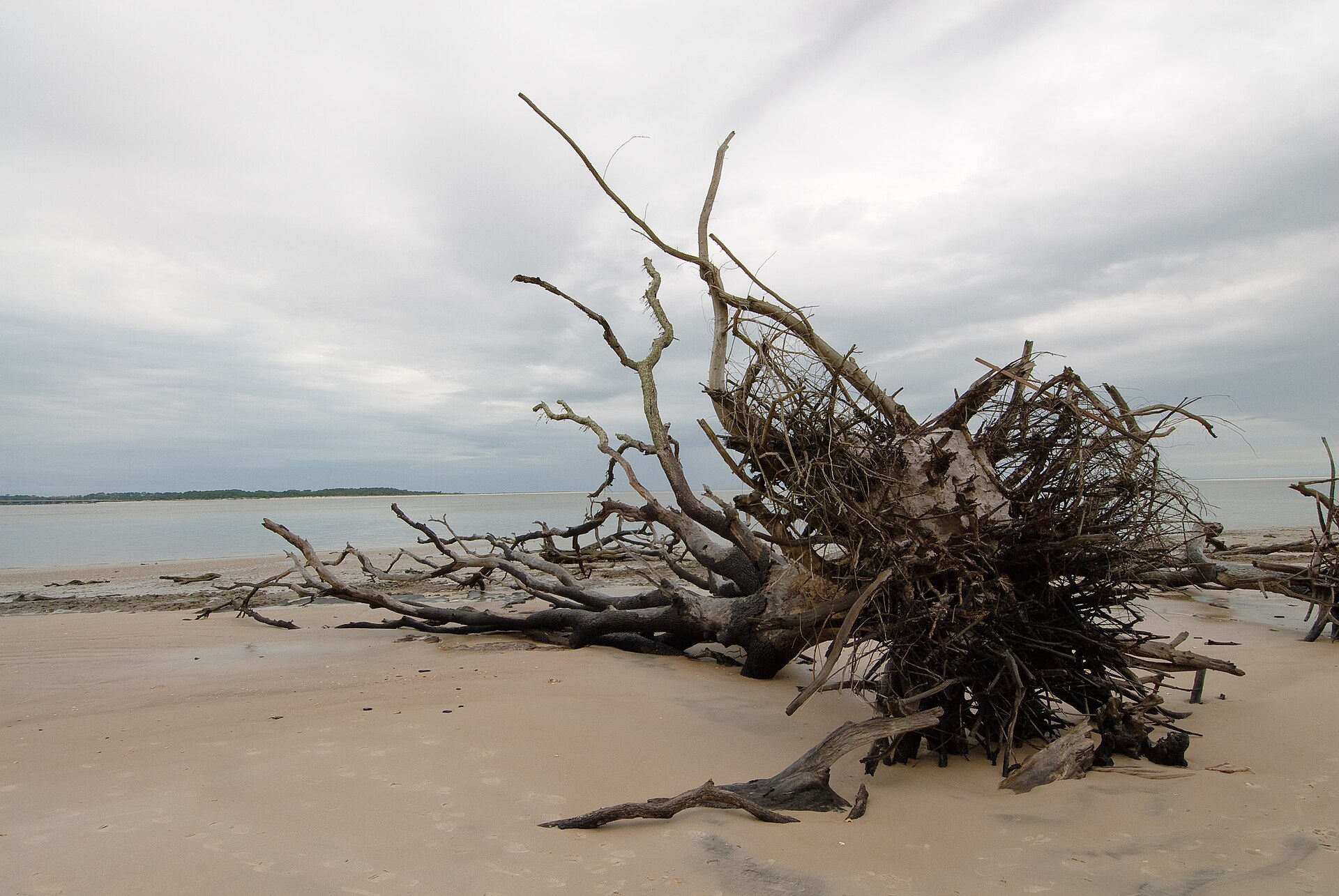
Boneyard Beach is known for its striking shoreline of fallen, weathered trees. The exposed trunks and roots are a defining part of the Big Talbot landscape and make this a standout photography and shoreline-walking destination. The display changes as tides, storms and erosion reposition the wood.
How to explore safely
Visit only on an open route and plan around the tide. Photograph the trees where they lie, keep clear of unstable trunks and rising water, and do not climb eroding bluffs or disturb wildlife shelter. Florida State Parks does not recommend swimming here because of strong currents and marine wildlife in Nassau Sound.
May I take it home?
Viewing only · collection prohibited. Florida State Parks explicitly prohibits gathering driftwood, including firewood and kindling. Leave small loose pieces as well as large logs in place. The published research or academic permit exception is not permission for souvenir collecting.
Rules & enforcement
Florida Statutes §258.008(1) allows ejection and a fine up to $500 for ordinary state-park rule violations. Other conduct may be charged under different provisions. These are statutory limits, not an automatic driftwood ticket; the applicable enforcement depends on the facts.
- Big Talbot Island: protected driftwood ↗
- Florida State Parks: collecting FAQ, question 1.8 ↗
- Florida Statutes §258.008: state-park offenses ↗
Reviewed September 30, 2026. Driftwood ratings describe viewing quality only and never grant collection permission.
Snorkeling & scuba · 1/5 from shore The park advises against swimming here.
Snorkeling & scuba diving
Ratings use local Duval County evidence and apply to entry from this beach. Offshore boat diving is separate.
SnorkelingThe park advises against swimming here.Visibility, wildlife & rentals +
What to expect
The park advises against swimming here. The 1/5 score signals poor suitability; it is not permission or a safety finding.
Underwater visibility
Variable and unmeasured at Boneyard Beach. No reliable beach-specific visibility range was found in the reviewed Duval County sources. Surf can suspend sand, and surface color is not an underwater visibility measurement.
Fish & sea life
The reviewed Duval County sources support local marine-habitat context but not a beach-specific underwater sighting census for Boneyard Beach. Fish and other sea life vary with season, water, depth and habitat; no species is promised.
Entry, conditions & experience
Do not plan snorkeling or a shore dive here. Florida State Parks advises against swimming because of strong currents and marine wildlife in Nassau Sound. Enjoy the driftwood shoreline from land.
This is not a designated beginner snorkeling recommendation. Go with a buddy and skip unsafe conditions.
Equipment rental nearby
Divers Supply Jacksonville advertises scuba rentals and requires a certification card. Confirm current inventory and directions directly. It is an off-beach shop, not a beach concession. Divers Supply Jacksonville: equipment rentals ↗
Scuba divingThe park advises against swimming here.Visibility, wildlife & rentals +
What to expect
The park advises against swimming here. The 1/5 score signals poor suitability; it is not permission or a safety finding.
Underwater visibility
Variable and unmeasured at Boneyard Beach. No reliable beach-specific visibility range was found in the reviewed Duval County sources. Surf can suspend sand, and surface color is not an underwater visibility measurement.
Fish & sea life
The reviewed Duval County sources support local marine-habitat context but not a beach-specific underwater sighting census for Boneyard Beach. Fish and other sea life vary with season, water, depth and habitat; no species is promised.
Entry, conditions & experience
Do not plan snorkeling or a shore dive here. Florida State Parks advises against swimming because of strong currents and marine wildlife in Nassau Sound. Enjoy the driftwood shoreline from land.
Use a trained buddy and stay within your certification. No recommended shore-dive route is established here.
Equipment rental nearby
Divers Supply Jacksonville advertises scuba rentals and requires a certification card. Confirm current inventory and directions directly. It is an off-beach shop, not a beach concession. Divers Supply Jacksonville: equipment rentals ↗
Shore & sky wildlife
Local Duval County evidence for animals on the sand, dunes and in the air. Underwater species are covered separately.
Birds on the shore & in the skyTerns, pelicans & seasonal shorebirdsDuval County coastal evidence
Jacksonville sources document royal terns, pelicans and other coastal birds along Duval’s oceanfront. Species and flock sizes at Boneyard Beach change with season, tide and habitat.
Sea turtles on the beachLoggerheads · nesting season May–OctoberJacksonville oceanfront evidence
Jacksonville Beach confirms local nesting and identifies loggerheads as the region’s most common nesting species. This county evidence does not establish a current nest at Boneyard Beach.
Other shore & dune wildlifeGopher tortoises, deer & raccoonsBig Talbot park-wide evidence
Big Talbot documents these animals along its trails. They are park-wide possibilities, not a promise of animals among the driftwood.
Wild horsesNo local wild herd documentedDuval County beach context
No reviewed Duval County source documents a free-roaming wild-horse herd at Boneyard Beach. Horseback riding, where permitted, involves domestic animals.
History & interesting facts
The stories behind this stretch of coast.
Natural historyWhy the beach has a “boneyard”
Location: Boneyard shoreline, Big Talbot Island
The pale trunks are fallen coastal trees, not a collection of shipwreck timbers. Erosion undermines the wooded bluff, dropping trees onto the shore; sun, salt and weather give them their bone-like appearance. The fallen trees also break up wave energy and help slow further erosion. Leave them in place as part of the protected landscape.
Florida State Parks · Boneyard Beach ↗Sources reviewed September 22, 2026. Historical sites and nearby filming locations may have separate access arrangements.
- Sand & shoreline
- Sandy patches among fallen trees
Documented driftwood shoreline; color unconfirmed. See Sand & sandcastles for details.
Florida State Parks: Boneyard Beach ↗ - Surfing
- Not a practical surf destination
Sound, inlet or protected shoreline. Shore exploration recommended instead of surfing. See the surfing profile and current reports for details.
Visit Jacksonville · Surf spot guide and local report resources ↗ - Water
- Nassau Sound shoreline
This profile is for shoreline exploration, not a swimming recommendation.
Florida State Parks · Big Talbot amenities ↗
Water clarity & shore snorkeling
Typical clarity: Not yet assessed. We do not yet have enough beach-specific evidence to describe typical underwater visibility. This does not mean the water is cloudy.
Shore snorkeling not yet assessed. A shore-snorkeling recommendation has not been established for this beach. Check the snorkeling section for access and restrictions.
Typical clarity describes how easily you may see through the water. It does not establish bacterial water quality, safe swimming, calm conditions or visibility today.
Evidence, location scope & review
Desk review 2026-10-06 · This named beach; neighboring beaches, offshore reefs and bacterial sample results excluded. This is not an on-site inspection or a current conditions report.
No beach-specific seasonal/tidal visibility pattern verified.
Named beach only; county offshore diving not inherited
Find clear-water and shore-snorkeling options ↗ · Report a change ↗
A closer look
Photos of this beach and its surroundings. Select a photo to view it larger. These are recorded views, not live conditions.
 View larger ↗
Fallen trees on Boneyard Beach, Big Talbot Island.
Taken: 2011-02-05 15:33Boneyard Beach (Florida).jpg · oliver.dodd · CC BY 2.0
Resized/cropped for display; original colors retained. Adaptations retain the stated license.
Food, stays & rentals
EXTEND YOUR BEACH DAY
Food & drink nearby
Local dining recommendations
Local seafood
Safe Harbor Seafood Restaurant
4378 Ocean Street · Mayport Village Waterfront Mayport restaurant; a drive from the ocean parks and not an on-beach concession.
Visit Safe Harbor Seafood Restaurant website ↗Website & source check
Website checked ↗ · Supporting source 2 ↗ · checked 2026-10-06. Current direct official page retrieved and archived; verification establishes operator identity/link, not today's service availability.
Seafood
Singleton's Seafood Shack
4728 Ocean Street · Mayport Village Mayport Village dining; separate from restricted Naval Station shoreline and oceanfront parks.
Visit Singleton's Seafood Shack website ↗Website & source check
Website checked ↗ · Supporting source 2 ↗ · Supporting source 3 ↗ · checked 2026-10-06. Direct request failed or was challenged; current primary page independently reviewed through the web retrieval/index. No direct-HTTP success is claimed.
These listings are unpaid and contain no affiliate links.
Accommodations by the beach
Verified coastal stays and nearby alternatives. Location labels distinguish oceanfront property, across-A1A lodging and regional options; confirm your exact room or rental unit.
The hotels and rentals below are outside this park, on other stretches of coast. No qualifying hotel, house or condo at this park’s beach has been verified. Camping is covered separately.
Hotel / resortOmni Amelia Island Resort & SpaBeachfront · Regional alternative · southern Amelia Island
Location: Southern Amelia Island · resort oceanfront
Ocean view: The hotel advertises ocean-view rooms with balconies. Villas are a separate product with differing locations and views.
This listing covers the oceanfront hotel, not every privately rented villa within the larger resort community.
Website/source checked 2026-10-06.
Condo rentalsShipwatch Villas · Amelia Island Beach Front RentalsBeachfront · Regional alternative · southern Amelia Island
Location: Shipwatch Villas · southern Amelia Island resort community
Ocean view: Owner-listed oceanfront condos; verify the exact unit, floor and balcony outlook.
A small owner rental collection. Resort membership privileges and hotel amenities must be confirmed separately; a condo booking does not establish full resort access.
Website/source checked 2026-10-06.
Before you book
Confirm the exact address, view category, road crossings, beach access and current photos. For rentals, verify bedrooms, occupancy, kitchen, parking, minimum stay and which pools or resort facilities are included. Compare the total including cleaning, resort and parking fees, deposits, taxes, pet charges and cancellation terms. Check accessibility directly with the property.
Property descriptions last checked 2026-09-22; rates and availability are not live. These listings are unpaid and contain no affiliate links. Rental collections are starting points for a search, not confirmation that every unit meets these criteria or is at this beach.
Activities & rentals
Choose by service and meeting place. Inland launches and regional outings are separate from this beach.
PADL · Amelia & Talbot IslandsKayaks & paddleboardsNearby · separate Talbot launch
Where: 13030 Heckscher Drive, Talbot Islands area
Kayak rentals listed by the operator. Use the designated launch and confirm the current rental arrangement; this is not a Boneyard oceanfront rental stand.
Service, meeting place & booking details ↗Amelia Island Horseback RidingHorseback ridingRegional outing · Peters Point
Where: Peters Point Beachfront Park, 4600 Peters Point Road
Guided beach rides. Reserve ahead and confirm rider requirements, seasonal schedule and meeting instructions.
Service, meeting place & booking details ↗Jet Ski AmeliaJet ski rentals & tours · Tours & cruisesRegional outing · Fernandina
Where: Downtown Fernandina Beach; confirm the exact dock when booking
Guided jet ski excursions, rather than unrestricted hourly hire. Check driver and passenger eligibility before booking.
Service, meeting place & booking details ↗Ocean Outboard MarineBoat rentalsRegional outing · Fernandina
Where: Business address: 1619 N. 14th Street, Fernandina Beach; confirm pickup / launch
Advertises boat rentals. Confirm available vessel, departure point, operating area and skipper requirements directly.
Service, meeting place & booking details ↗Amelia River CruisesTours & cruisesRegional outing · Fernandina
Where: Alliance Marina at Fernandina Harbor Marina, downtown Fernandina Beach
Narrated sightseeing and wildlife cruises. Cumberland Island horses are viewed on Cumberland, not on the selected Florida beach; sightings vary.
Service, meeting place & booking details ↗Amelia Island Tours & ChartersFishing charters · Tours & cruisesRegional charter · confirm departure
Where: Amelia Island area; exact departure must be confirmed with the captain
Inshore fishing, wildlife trips and private boat tours. Ask about party size, included equipment and the trip suited to your group.
Service, meeting place & booking details ↗Operator information last checked 2026-09-22. Confirm current schedules, prices, weather cancellations, accessibility and the exact meeting point. These listings are unpaid and contain no affiliate links.
Explore nearby beaches
Review dates & updates
Dates below cover the named fact and its recorded evidence, not an on-site inspection or today’s conditions.
No matching field-specific review dates are recorded here yet. See the guide sources for their stated scope.
Closure and condition evidence gets the shortest review cycle; fees, hours and seasonal staffing are checked more often than stable geography. Changed or conflicting evidence goes into a scoped review queue. How reviews work
Sources & review date
Guide desk research reviewed 2026-09-22; this is not a field-by-field current verification or an on-site inspection. Official facts, dated agency evidence and editorial assessments retain their own scope. Unknowns and conflicts remain open. Methodology · Rating explanations · Correction history
- Florida State Parks · General rules and service animals ↗
- Florida State Parks · Big Talbot Island ↗
- Florida State Parks · Big Talbot amenities ↗
- Big Talbot Island · Parking admission ↗
- Florida State Parks: Boneyard Beach ↗
- Visit Jacksonville · Surf spot guide and local report resources ↗
- Visit Jacksonville · Mayport Village dining ↗
Photo: Boneyard Beach (Florida).jpg by oliver.dodd · CC BY 2.0. Cropped for display; adaptations retain this license.

Visitor experiences
Original, moderated reviews and photographs. Visit dates and entrances provide context; visitor ratings and reports do not replace official facts or current conditions.
Read approved visitor experiences here when available.