
Tidal Potomac · Virginia
Caledon State Park Beach / Boyd’s Hole
- State
- Virginia
- County
- King George
- City / community
- King George
King George is the mailing/nearby area; Caledon State Park Beach / Boyd’s Hole is in King George County.
Tidal Potomac
A trail-access Potomac shore reached through Caledon State Park’s wooded landscape. Plan a substantial walk, respect management closures and distinguish the shoreline from the separately reserved primitive campground.
Good fit: A trail-access Potomac shore reached through Caledon State Park’s wooded landscape. Plan a substantial walk, respect management closures and distinguish the shoreline from the separately reserved primitive campground.
Plan around: Check the entrance-specific route and equipment details below before planning your visit.
- Parking
- Park parking fee
Details & sources
- Dogs
- Confirm exact beach scope
Details & sources
Confirm exact beach scope
Keep dogs attended and on a leash no longer than six feet on permitted park routes. No dog-bathing entitlement or access through posted closures is inferred.
Caledon State Park Beach / Boyd’s Hole · dogs ↗ - Restrooms
- See facility scope
Details & sources
See facility scope
Visitor-center restrooms and a portable toilet near the picnic shelter are listed inland. Current toilet provision at the Boyd’s Hole sand and showers were not established.
Caledon State Park Beach / Boyd’s Hole · restrooms showers ↗ - Lifeguards
- Coverage unconfirmed
Details & sources
Coverage unconfirmed
A lifeguard program or current staffing schedule was not verified. Do not plan on supervised swimming.
Caledon State Park Beach / Boyd’s Hole · lifeguards ↗ - Key restrictions
- Check before you go
Details & sources
Follow designated open trails, management closure notices and signed natural areas. No designated swimming area. Campground paddle landing is separate from general motorized boating restrictions.
Caledon State Park Beach / Boyd’s Hole · public access rules ↗ - Best for
- See beach overview
Beach overview
A trail-access Potomac shore reached through Caledon State Park’s wooded landscape. Plan a substantial walk, respect management closures and distinguish the shoreline from the separately reserved primitive campground.
Sources & review dates
More planning facts: access, driving & fees
- Public access
- Public accessDetails & restrictions
- Beach driving
- Beach driving rulesDetails & restrictions
- Accessibility
- Confirm route to sandDetails & restrictions
Approximate named beach-shore planning reference only; not navigation waypoint, surveyed boundary, exact entrance coordinate, legal crossing entitlement, current opening or continuous accessible route.
Choose an entrance
11617 Caledon Road; designated trail to Potomac shoreline
Enter Caledon and follow the designated Boyd’s Hole trail to the open Potomac shoreline. Respect management closures; campground landing rules are a separate scope.
Official route / restriction details ↗Review dates & updates
These dates record desk research of each named category, including searches that left a fact unresolved. They are not on-site inspections, current-opening confirmations or water-safety observations.
- identity location: research reviewed 2026-10-25 · verified
- summary description: research reviewed 2026-10-25 · verified
- known for: research reviewed 2026-10-25 · verified
- live weather: research reviewed 2026-10-25 · unresolved
- daily forecast: research reviewed 2026-10-25 · unresolved
- tides: research reviewed 2026-10-25 · unresolved
- surf rip forecast: research reviewed 2026-10-25 · unresolved
- official flags closures: research reviewed 2026-10-25 · verified
- water quality: research reviewed 2026-10-25 · unresolved
- public access: research reviewed 2026-10-25 · verified
- crowds: research reviewed 2026-10-25 · verified
- sand shoreline: research reviewed 2026-10-25 · verified
- surf: research reviewed 2026-10-25 · unresolved
- shelling: research reviewed 2026-10-25 · unresolved
- shark teeth: research reviewed 2026-10-25 · verified
- sea glass: research reviewed 2026-10-25 · unresolved
- driftwood: research reviewed 2026-10-25 · verified
- snorkeling: research reviewed 2026-10-25 · unresolved
- scuba: research reviewed 2026-10-25 · unresolved
- wildlife: research reviewed 2026-10-25 · verified
- accommodations: research reviewed 2026-10-25 · verified
- commercial activities rentals: research reviewed 2026-10-25 · verified
- alcohol rules: research reviewed 2026-10-25 · verified
- fire rules: research reviewed 2026-10-25 · verified
- camping rules: research reviewed 2026-10-25 · verified
- shore fishing rules: research reviewed 2026-10-25 · verified
- hours: research reviewed 2026-10-25 · verified
- dogs: research reviewed 2026-10-25 · unresolved
- lifeguards: research reviewed 2026-10-25 · unresolved
- restrooms showers: research reviewed 2026-10-25 · verified
- parking entry: research reviewed 2026-10-25 · verified
- accessibility: research reviewed 2026-10-25 · unresolved
- driving: research reviewed 2026-10-25 · unresolved
- public access rules: research reviewed 2026-10-25 · verified
- dining: research reviewed 2026-10-25 · verified
- history: research reviewed 2026-10-25 · verified
- managing authority: research reviewed 2026-10-25 · verified
- official source links: research reviewed 2026-10-25 · verified
- main photo: research reviewed 2026-10-25 · verified
- photo gallery: research reviewed 2026-10-25 · verified
- admission payment passes: research reviewed 2026-10-25 · verified
- plan your visit: research reviewed 2026-10-25 · verified
- check before you go: research reviewed 2026-10-25 · verified
- nearby beaches: research reviewed 2026-10-25 · verified
- closer look: research reviewed 2026-10-25 · unresolved
Current advisories and changing seasonal facilities need separate checks. Unknowns retain their stated limitations and follow-up work. How reviews work
Parking, route & accessibility evidence
Parking & entry: Park parking fee. Pay the parking fee at the self-pay station before parking; use designated areas and bring cash or a valid parking pass if needed because cellular service is limited.
Parking source ↗Accessibility: Confirm route to sand. Accessible inland picnic/visitor facilities do not establish the long Boyd’s Hole trail and sand as a continuous accessible beach route.
Accessibility source ↗Open the county entrance directory ↗
Use the directory to check each entrance’s identity and status. Guide map pins are approximate shoreline locations, not turn-by-turn entrance directions or proof of current opening.
Known for
A wooded trail approach to the Potomac and the park’s bald-eagle habitat; shoreline access is not a designated swimming area.
Sources & review dates
known for
Source ↗ · reviewed 2026-10-25
Rules & facilities
Check before you go
Recheck the responsible manager’s current notices, exact route/facility operation, weather and any exact-station water advisory. Photos and saved reports are dated evidence, not continuous opening or safety guarantees.
Sources & review dates
check before you go
Source ↗ · reviewed 2026-10-25
Admission, payment & passes
A state-park parking fee applies; consult the current official schedule and paystation instructions. Any reserved campsite, rental or event charge is separate.
Sources & review dates
admission payment passes
Source ↗ · reviewed 2026-10-25
What to bring & supporting visit details
Plan your visit
Budget time for the trail walk, pay parking, carry drinking water and check closure notices. Visitor-center facilities and remote shoreline/campground facilities are separate.
Sources & review dates
plan your visit
Source ↗ · reviewed 2026-10-25
Public or private?
Public access
Who can visit: Enter Caledon and follow the designated Boyd’s Hole trail to the open Potomac shoreline. Respect management closures; campground landing rules are a separate scope.
Entry route, fees & access boundaries
- Manager / access authority
- Virginia DCR, Caledon State Park
- Access basis
- Enter Caledon and follow the designated Boyd’s Hole trail to the open Potomac shoreline. Respect management closures; campground landing rules are a separate scope.
- Where to enter
- Enter Caledon and follow the designated Boyd’s Hole trail to the open Potomac shoreline. Respect management closures; campground landing rules are a separate scope.
- Fees & reservations
- A state-park parking fee applies; consult the current official schedule and paystation instructions. Any reserved campsite, rental or event charge is separate.
- Restrictions & exceptions
- Follow designated open trails, management closure notices and signed natural areas. No designated swimming area. Campground paddle landing is separate from general motorized boating restrictions.
- What this label covers
- Named coastal planning reference, not surveyed boundaries or a navigation waypoint.
Beach ownership, the route across land, public shoreline-use rights and access to facilities are separate questions. Rules vary by state and location. Use the identified public entrance or documented permission; neither a nearby resort nor an admission fee by itself establishes that a beach is private. A mapped beach is not permission to cross private property.
Access policy reviewed 2026-10-25. Not a live closure report or a property-boundary survey.
Allowed & prohibited activities
Alcohol: Park trail guidance limits alcohol use to private camping/cabin units or specifically permitted areas. No ordinary beach exception is established.
Fires and grills: Use only designated grills, camp stoves or fire rings and obey current fire restrictions. No unprovided beach-fire location is authorized.
Overnight camping: Six primitive waterfront campsites require reservations and hike/bike/paddle access. No vehicle access or potable campground water. Campground canoe/kayak landing is a specific exception to generic boating text.
Shore fishing: Fishing is allowed along open Potomac areas, not Jones Pond or Caledon Marsh. Confirm applicable tidal-water license and current closed shore sections.
- Hours
- Hours & seasonal limits
8 a.m. to sunset; resource-management closures and office/visitor-center hours are separate.
Caledon State Park Beach / Boyd’s Hole · hours ↗ - Dogs on the beach
- Confirm exact beach scope
Keep dogs attended and on a leash no longer than six feet on permitted park routes. No dog-bathing entitlement or access through posted closures is inferred.
Caledon State Park Beach / Boyd’s Hole · dogs ↗ - Lifeguards
- Coverage unconfirmed
A lifeguard program or current staffing schedule was not verified. Do not plan on supervised swimming.
Caledon State Park Beach / Boyd’s Hole · lifeguards ↗ - Restrooms
- See facility scope
Visitor-center restrooms and a portable toilet near the picnic shelter are listed inland. Current toilet provision at the Boyd’s Hole sand and showers were not established.
Caledon State Park Beach / Boyd’s Hole · restrooms showers ↗ - Access & beach rules
- Rules & restrictions
Follow designated open trails, management closure notices and signed natural areas. No designated swimming area. Campground paddle landing is separate from general motorized boating restrictions.
Caledon State Park Beach / Boyd’s Hole · public access rules ↗ - Beach driving
- Beach driving rules
Use designated roads and parking. No ordinary motor-vehicle beach-driving authorization was established.
Caledon State Park Beach / Boyd’s Hole · driving ↗
Conditions & activities Surf, sand, wildlife and suitability
Conditions at the beach
Local times use Eastern Time. No beach observation or current saved forecast is published here. External sources retain their own forecast issue, observation, prediction, sample and retrieval clocks. Source qualification reviewed October 25, 2026 is not an observation time.
Official source links and saved records
Weather observation
Unavailable here: no exact beach weather observation or observation station is assigned. The linked forecast is a prediction, not an observation.
National Weather Service point forecast ↗Daily forecast
No current forecast cache is shown. Open the responsible NWS point forecast for these approximate planning coordinates and check its issue time and location scope.
Open the NWS forecast ↗High & low tides
No local tide station or beach timing is assigned. Choose an applicable station in the NOAA directory and check its location, datum and prediction dates. Predictions are not observed water levels or safe crossing times.
NOAA tide-station selection portal ↗Regional marine forecast
Use the per-guide National Weather Service marine source selected by the responsible forecast office for this planning point. Choose the zone matching this part of the tidal Potomac; a forecast-office assignment is not a county or shoreline boundary. Regional predictions are not observed beach flags, a swimming assessment or a current closure report.
Responsible NWS marine source overview ↗Closures, flags & water quality
DCR warns of resource-management closure days in November and December. Check current Park Alerts for actual dates; no beach warning-flag observation was verified.
Use VDH’s exact monitored beach/station and sample/advisory dates if assigned; no current safe-water claim is made. Regional shellfish or drinking-water reports are different scopes.
Virginia Department of Health beach monitoring ↗: exact station, sample date and applicable advisory must be checked separately. No nearby sample is assigned to this beach by proximity.
Crowd meter
DCR warns parking is limited; arrive early and park only in designated spaces. No hour-by-hour beach crowd estimate is established.
Sources & review dates
crowds
Source ↗ · reviewed 2026-10-25
Sand & sandcastles
The park’s trail reaches the Potomac shore; exact usable sand extent varies and is not surveyed here.
Sources & review dates
sand shoreline
Source ↗ · reviewed 2026-10-25
Surfing profile
No measured typical wave or safe-bathing rating is established for this tidal shoreline. Wind, tides and boat wakes can matter.
Sources & review dates
surf
Source ↗ · research reviewed 2026-10-25
Beachcombing
Fossil shells are described in a historical DCR beach account; current ordinary shell-collection limits need park clarification.
A DCR account describes fossil shark teeth, fossil shells and crocodile teeth along Caledon’s Potomac beach. Treat this as a historical site-specific feature account, not proof of current collection permissions or guaranteed finds.
Snorkeling & scuba diving
No verified recreational shore-snorkel or scuba entry, offshore excursion or typical underwater-clarity rating was established. Boat or kayak transport is a separate activity.
No verified recreational shore-snorkel or scuba entry, offshore excursion or typical underwater-clarity rating was established. Boat or kayak transport is a separate activity.
Sources & review dates
snorkeling · scuba
Source ↗ · research reviewed 2026-10-25
Clothing-optional, nudity & topless sunbathing
No verified permission or designated clothing-optional area is established for this named shore. Source silence is not permission; it is excluded from verified full-nudity matches.
A separate beach-specific ruling permitting female-topless sunbathing is not established. It is excluded from verified topless matches.
Water clarity & shore snorkeling
Typical clarity: Not yet assessed. Typical underwater clarity is not assessed for this named shore. Water color, bacterial results and forecasts do not measure visibility.
Shore snorkeling not yet assessed. No verified recreational shore-snorkel or scuba entry, offshore excursion or typical underwater-clarity rating was established. Boat or kayak transport is a separate activity.
Typical clarity describes how easily you may see through the water. It does not establish bacterial water quality, safe swimming, calm conditions or visibility today.
Evidence, location scope & review
Desk review 2026-10-25 · Caledon State Park Beach / Boyd’s Hole. This is not an on-site inspection or a current conditions report.
Caledon State Park Beach / Boyd’s Hole
Find clear-water and shore-snorkeling options ↗ · Report a change ↗
Shore & sky wildlife
Caledon is recognized by DCR for old-growth forest and its summering bald-eagle population. Observe wildlife from designated routes and honor seasonal management closures.
Sources & review dates
wildlife
Source ↗ · reviewed 2026-10-25
History & interesting facts
DCR describes Caledon’s Alexander/Smoot family history and its 1974 donation; it became a state park in 2012. Historical natural-area restrictions must be checked against current park rules.
Sources & review dates
history
Source ↗ · reviewed 2026-10-25
- Sand & shoreline
- Sand & shore character
The park’s trail reaches the Potomac shore; exact usable sand extent varies and is not surveyed here.
Caledon State Park Beach / Boyd’s Hole · sand shoreline ↗ - Surfing
- Surf suitability unrated
No measured typical wave or safe-bathing rating is established for this tidal shoreline. Wind, tides and boat wakes can matter.
Caledon State Park Beach / Boyd’s Hole · surf ↗ - Water
- Dated sample information
Use VDH’s exact monitored beach/station and sample/advisory dates if assigned; no current safe-water claim is made. Regional shellfish or drinking-water reports are different scopes.
Caledon State Park Beach / Boyd’s Hole · water quality ↗
A closer look
Photos of this beach and its surroundings. Select a photo to view it larger. These are recorded views, not live conditions.
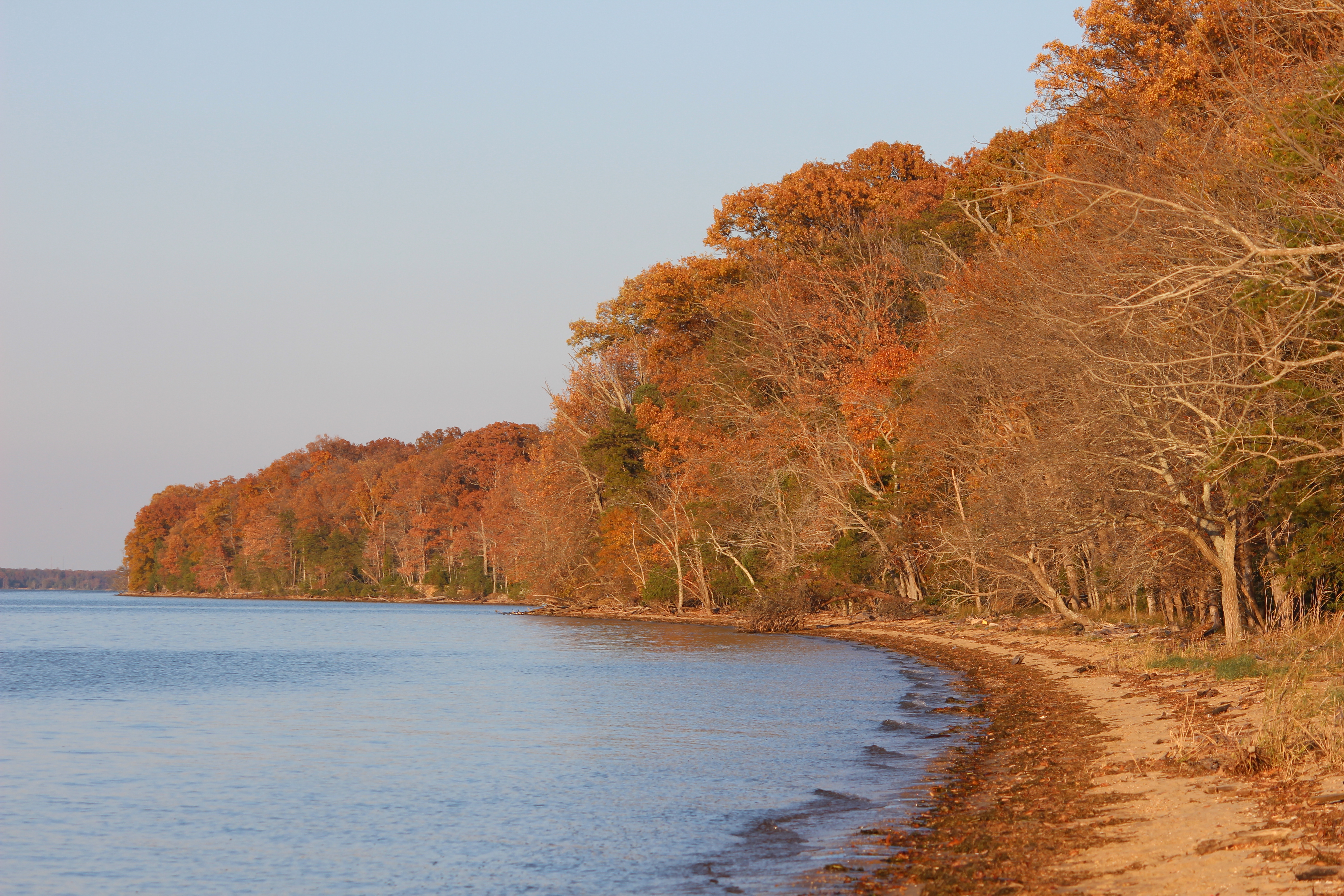 View larger ↗
Boyd’s Hole beach at Caledon State Park, November 27, 2016. Virginia State Parks, CC BY2.0. Display copies cropped, resized and converted to WebP.
Taken: 2016-11-27As Fall Slips Away on the Beach (32649535372) · Virginia State Parks · CC BY 2.0
Resized/cropped for display; original colors retained. Adaptations retain the stated license.
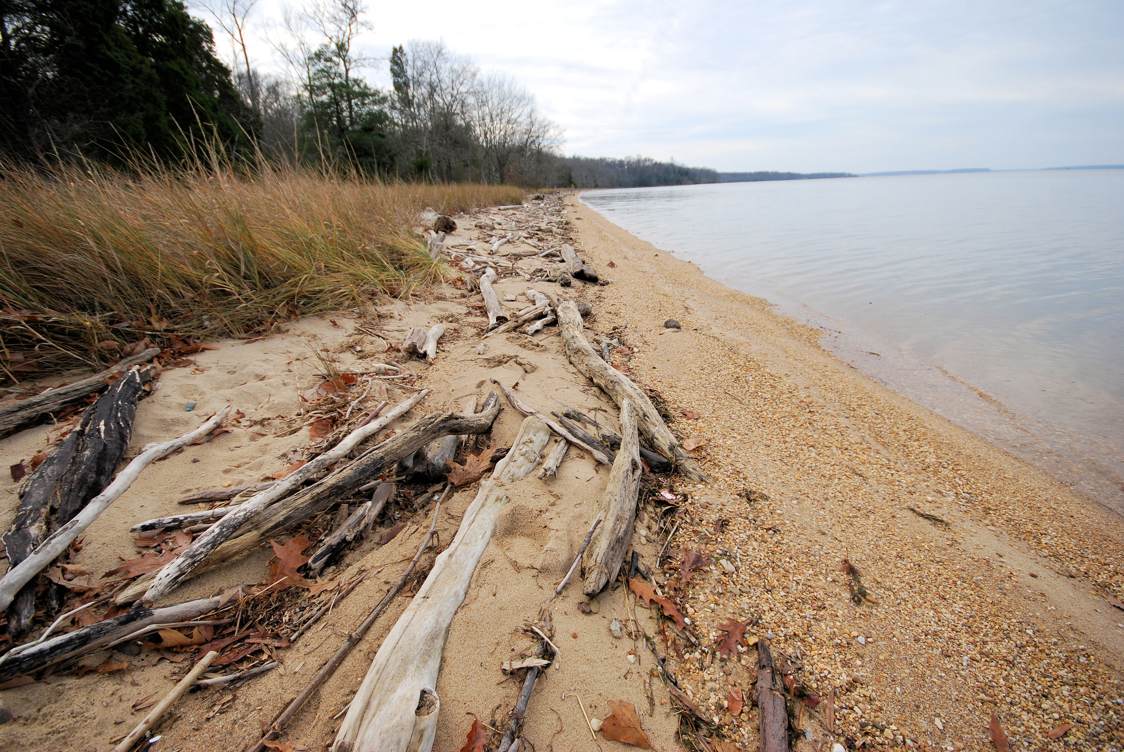 View larger ↗
Boyd’s Hole beach at Caledon State Park, December 20, 2012. Virginia State Parks, CC BY2.0. Display copies cropped, resized and converted to WebP.
Taken: 2012-12-20Caledon Boyds Hole Trail beach (8299702429) · Virginia State Parks staff · CC BY 2.0
Resized/cropped for display; original colors retained. Adaptations retain the stated license.
Food, stays & rentals
EXTEND YOUR BEACH DAY
Food & drink nearby
Local dining recommendations
Food & drink
Tim’s II at Fairview
Restaurant/crabhouse service in King George County. This association does not establish public access to the separately held Fairview Beach candidate.
5411 Pavilion Drive, King George; separate restaurant property
Visit Tim’s II at Fairview website ↗Website & source check
Website checked ↗ · checked 2026-10-25 (Eastern Time). Confirm current opening, eligibility, hours, prices and booking directly. A separate service grants no beach crossing, landing or continuous accessible route.
Research notes & location scope
Tim’s II at Fairview at 5411 Pavilion Drive is a separate restaurant/crabhouse in King George County. Check current service directly; dining does not establish public access to Fairview Beach.
Supporting research source ↗ · reviewed 2026-10-25
These listings are unpaid and contain no affiliate links.
Accommodations by the beach
Accommodation
My Place Hotel – Dahlgren/King George
Book separate hotel lodging directly; this is not an on-site state/county park accommodation.
4235 Market Center Drive, King George; separate hotel
Visit My Place Hotel – Dahlgren/King George website ↗Website & source check
Website checked ↗ · checked 2026-10-25 (Eastern Time). Confirm current opening, eligibility, hours, prices and booking directly. A separate service grants no beach crossing, landing or continuous accessible route.
Before you book
Confirm the exact property or rental unit, view category, beach route, accessibility and total price directly. Nearby lodging does not establish access to a private beach, a boat transfer or permission to camp.
Research notes & location scope
My Place Hotel–Dahlgren/King George at 4235 Market Center Drive offers separate hotel lodging in King George County. Check rooms and booking terms directly; no beach-front access or park accommodation is implied.
Supporting research source ↗ · reviewed 2026-10-25
These listings are unpaid and contain no affiliate links.
Activities & rentals
Machodoc Creek Marina at 17088 Ferry Dock Road offers separate kayak, canoe and stand-up paddleboard rentals. Confirm the actual launch and route with the operator. This is not a Caledon on-site service or permission to land on protected shore.
Sources & review dates
commercial activities rentals
Source ↗ · reviewed 2026-10-25
Explore nearby beaches
Sources & review date
Guide desk research reviewed 2026-10-25; this is not a field-by-field current verification or an on-site inspection. Official facts, dated agency evidence and editorial assessments retain their own scope. Unknowns and conflicts remain open. Methodology · Rating explanations · Correction history
- Caledon State Park Beach / Boyd’s Hole · identity location ↗
- Caledon State Park Beach / Boyd’s Hole · summary description ↗
- Caledon State Park Beach / Boyd’s Hole · known for ↗
- Caledon State Park Beach / Boyd’s Hole · live weather ↗
- Caledon State Park Beach / Boyd’s Hole · daily forecast ↗
- Caledon State Park Beach / Boyd’s Hole · tides ↗
- Caledon State Park Beach / Boyd’s Hole · surf rip forecast ↗
- Caledon State Park Beach / Boyd’s Hole · official flags closures ↗
- Caledon State Park Beach / Boyd’s Hole · water quality ↗
- Caledon State Park Beach / Boyd’s Hole · public access ↗
- Caledon State Park Beach / Boyd’s Hole · crowds ↗
- Caledon State Park Beach / Boyd’s Hole · sand shoreline ↗
- Caledon State Park Beach / Boyd’s Hole · surf ↗
- Caledon State Park Beach / Boyd’s Hole · shelling ↗
- Caledon State Park Beach / Boyd’s Hole · shark teeth ↗
- Caledon State Park Beach / Boyd’s Hole · sea glass ↗
- Caledon State Park Beach / Boyd’s Hole · driftwood ↗
- Caledon State Park Beach / Boyd’s Hole · snorkeling ↗
- Caledon State Park Beach / Boyd’s Hole · scuba ↗
- Caledon State Park Beach / Boyd’s Hole · wildlife ↗
- Caledon State Park Beach / Boyd’s Hole · accommodations ↗
- Caledon State Park Beach / Boyd’s Hole · commercial activities rentals ↗
- Caledon State Park Beach / Boyd’s Hole · alcohol rules ↗
- Caledon State Park Beach / Boyd’s Hole · fire rules ↗
- Caledon State Park Beach / Boyd’s Hole · camping rules ↗
- Caledon State Park Beach / Boyd’s Hole · shore fishing rules ↗
- Caledon State Park Beach / Boyd’s Hole · hours ↗
- Caledon State Park Beach / Boyd’s Hole · dogs ↗
- Caledon State Park Beach / Boyd’s Hole · lifeguards ↗
- Caledon State Park Beach / Boyd’s Hole · restrooms showers ↗
- Caledon State Park Beach / Boyd’s Hole · parking entry ↗
- Caledon State Park Beach / Boyd’s Hole · accessibility ↗
- Caledon State Park Beach / Boyd’s Hole · driving ↗
- Caledon State Park Beach / Boyd’s Hole · public access rules ↗
- Caledon State Park Beach / Boyd’s Hole · dining ↗
- Caledon State Park Beach / Boyd’s Hole · history ↗
- Caledon State Park Beach / Boyd’s Hole · managing authority ↗
- Caledon State Park Beach / Boyd’s Hole · official source links ↗
- Caledon State Park Beach / Boyd’s Hole · main photo ↗
- Caledon State Park Beach / Boyd’s Hole · photo gallery ↗
- Caledon State Park Beach / Boyd’s Hole · admission payment passes ↗
- Caledon State Park Beach / Boyd’s Hole · plan your visit ↗
- Caledon State Park Beach / Boyd’s Hole · check before you go ↗
- Caledon State Park Beach / Boyd’s Hole · nearby beaches ↗
- Caledon State Park Beach / Boyd’s Hole · closer look ↗
Photo: As Fall Slips Away on the Beach (32649535372) by Virginia State Parks · CC BY 2.0. Cropped for display; adaptations retain this license.

Visitor experiences
Original, moderated reviews and photographs. Visit dates and entrances provide context; visitor ratings and reports do not replace official facts or current conditions.
Read approved visitor experiences here when available.