
Mississippi Barrier Islands · Mississippi
Deer Island
- State
- Mississippi
- County
- Harrison County
- City / community
- Biloxi offshore
US-MS-harrison-sound-coast · Mississippi Barrier Islands
Deer Island is a boat-access coastal preserve close to Biloxi, with state-owned sandy shore and wildlife habitat. Keep state land, posted closures and any private parcels separate; swimming and snorkeling permission need a scoped DMR clarification.
Good fit: Deer Island is a boat-access coastal preserve close to Biloxi, with state-owned sandy shore and wildlife habitat. Keep state land, posted closures and any private parcels separate; swimming and snorkeling permission need a scoped DMR clarification.
Plan around: See the entrance section for accessibility details and sources.
PLAN THE BASICS
At a glance
- Parking
- Parking & entry · see routeDetails & restrictions
- Dogs
- Yes · restrictions applyDetails & restrictions
- Restrooms
- Unknown · clarification pendingDetails & restrictions
- Lifeguards
- Unknown · clarification pendingDetails & restrictions
- Public access
- Public accessDetails & restrictions
- Beach driving
- NoDetails & restrictions
- Accessibility
- Route & sand gaps · see detailsDetails & restrictions
Choose an entrance
State-owned Deer Island sand shore; lawful boat landing must respect posted closures
Use only lawful boat landings on the responsible public unit; consult current charts and posted closures. Do not cross private island parcels or assume every shore landing is public. Authority listing is separate from a same-day opening report.
Official route / restriction details ↗Parking, route & accessibility evidence
Parking & entry: Parking & entry · see route. Boat-only arrival requires a lawful mainland departure and public-unit landing. A departure parking fee or private charter price is not an island beach admission fee.
Accessibility: Route & sand gaps · see details. No verified continuous accessible boat-landing-to-sand route, mat or beach-chair service is established. Mainland ramp accessibility does not establish island accessibility.
Open the county entrance directory ↗
Use the directory to check each entrance’s identity and status. Guide map pins are approximate shoreline locations, not turn-by-turn entrance directions or proof of current opening.
Known for
Boat-access island shoreline and coastal wildlife habitat; ownership and posted nesting closures determine where visitors may land and walk.
Sources & review dates
known for
Source ↗ · reviewed 2026-10-07
Rules & facilities
Check before you go
Check responsible-manager notices, dated water-quality information and the exact arrival. A saved sample or forecast is not current swimming safety; permission and facilities may be different at another entrance.
Sources & review dates
check before you go
Source ↗ · reviewed 2026-10-07
Admission, payment & passes
Current public-unit admission fees, boat-departure parking charges and private transport prices have not all been independently established; check each separately.
Sources & review dates
admission payment passes
Source ↗ · reviewed Date not recorded
What to bring & supporting visit details
Plan your visit
Start at State-owned Deer Island sand shore; lawful boat landing must respect posted closures. Confirm the exact route, operating facilities and any posted closures before travel. Keep transport, parking, beach rules and water conditions separate.
Sources & review dates
plan your visit
Source ↗ · reviewed 2026-10-07
Public or private?
Public access
Who can visit: Visitors using the named public route, subject to posted and managing-authority restrictions.
Entry route, fees & access boundaries
- Manager / access authority
- Mississippi Department of Marine Resources manages state-owned Deer Island Coastal Preserve; private parcels retain separate rights.
- Access basis
- Use only lawful boat landings on the responsible public unit; consult current charts and posted closures. Do not cross private island parcels or assume every shore landing is public.
- Where to enter
- Use only lawful boat landings on the responsible public unit; consult current charts and posted closures. Do not cross private island parcels or assume every shore landing is public.
- Fees & reservations
- See the entrance section for parking and entry details and sources.
- Restrictions & exceptions
- DMR Rule 10.1 requires permission for activities beyond listed hiking, hunting, fishing, wildlife watching and exempt camping. Swimming and snorkeling need DMR interpretation; do not promote an old recreation inventory as current permission.
- What this label covers
- Named public route only; no surveyed outer boundary or right across adjacent private property.
Beach ownership, the route across land, public shoreline-use rights and access to facilities are separate questions. Rules vary by state and location. Use the identified public entrance or documented permission; neither a nearby resort nor an admission fee by itself establishes that a beach is private. A mapped beach is not permission to cross private property.
Access policy reviewed 2026-10-07. Not a live closure report or a property-boundary survey.
Allowed & prohibited activities
Alcohol: Alcohol rules are not confirmed for this beach.
What still needs confirmation
A current island-unit visitor alcohol policy has not been established; no glass rules do not prove alcohol prohibition.
Fires and grills: DMR permits bare-sand fires near water subject to burn bans, extinguishment and vegetation/fuel restrictions.
Overnight camping: DMR allows camping only on state-owned sand beaches of Deer and Cat Island, generally no more than seven consecutive days without written permission. Maintain the 300-foot nesting-bird/eagle/osprey buffer.
Shore fishing: DMR permits fishing subject to local, state and federal rules; applicable licenses and posted wildlife closures still apply.
- Hours
- Hours · check named route
DMR state-owned Deer Island and Cat Island units are ordinarily open 24 hours under Rule 3.3, subject to posted partial closures at any time.
Deer Island · hours ↗ - Dogs on the beach
- Dogs · restrictions apply
Dogs are allowed on DMR coastal preserves, including state-owned Deer Island shore, on leash at all times with waste removal.
Deer Island · dogs ↗ - Lifeguards
- Exact staffing unconfirmed
No responsible entrance-specific lifeguard program and season have been established. This is an unknown, not a verified absence.
- Restrooms
- Facilities · see scoped details
A current operating island restroom or rinse has not been established. Primitive recreation does not itself prove every facility absent.
- Access & beach rules
- Named manager rules
DMR Rule 10.1 requires permission for activities beyond listed hiking, hunting, fishing, wildlife watching and exempt camping. Swimming and snorkeling need DMR interpretation; do not promote an old recreation inventory as current permission.
Deer Island · public access rules ↗ - Beach driving
- Beach driving · see rules
Ordinary visitor motor vehicles are prohibited on preserve vegetation and surrounding land; authorized operational exceptions do not establish a public drive-on beach.
Deer Island · driving ↗
Conditions & activities Surf, sand, wildlife and suitability
Conditions at the beach
Official source links and saved records below may be out of date. Forecasts, sample dates, observed flags and source retrieval times are separate. Times at this destination use Central Time.
Weather observation
Use the National Weather Service New Orleans/Baton Rouge office for regional weather. No dated beach-sensor observation is assigned; forecasts are not observed conditions.
Official weather observation source ↗
Source retrieved 2026-10-07T14:00:33.136Z; this is not an observation time.
Daily forecast
Use the official NWS office and marine forecasts for this arrival. No exact named shore forecast point is assigned; mainland forecasts are not substituted for an island landing.
Official daily forecast source ↗
Source retrieved 2026-10-07T14:00:33.136Z; this is not an observation time.
Tide predictions
No island-specific tide prediction station is assigned. Check NOAA charts and station metadata for the actual landing; mainland station timing does not establish island crossing or landing safety.
Official tide predictions source ↗
Source retrieved 2026-10-07T14:00:33.131Z; this is not an observation time.
Surf and rip-current forecast
NWS regional beach and marine forecasts are predictions, not observed warning flags. Mainland Mississippi Sound and sheltered Biloxi Bay are distinct from the islands’ Gulf-facing shores; no Gulf risk category is applied to a sheltered shore.
Official surf and rip-current forecast source ↗
Source retrieved 2026-10-07T14:00:33.136Z; this is not an observation time.
Local flags and closures
Check the named managing authority and posted notices for temporary work, closures and restrictions. No dated observed warning flag is assigned.
Official local flags and closures source ↗
Source retrieved 2026-10-07T14:01:29.465274+00:00; this is not an observation time.
Water quality
No exact MDEQ beach-sampling segment is assigned to this destination. Nearby monitored mainland segments do not establish this shore’s water quality or current swimming safety.
Official water quality source ↗
Source retrieved 2026-10-07T14:00:33.017Z; this is not an observation time.
Crowd meter
Crowds: not established at this arrival.
Sources & review dates
crowds
Source ↗ · reviewed Date not recorded
Sand & sandcastles
Public-unit sandy island shore is distinct from vegetated interior and closed nesting areas. Tide-dependent shore access and private parcels prevent a blanket whole-island public-access claim.
Sources & review dates
sand shoreline
Source ↗ · reviewed 2026-10-07
Surfing profile
A specific documented surf break and typical wave-height rating have not been established. Island shore orientation alone is not a surf recommendation.
Sources & review dates
surf
Source ↗ · reviewed Date not recorded
Beachcombing
Shelling: not established at this arrival.
Shark teeth: not established at this arrival.
Sources & review dates
shelling · shark teeth
Source ↗ · reviewed Date not recorded
Snorkeling & scuba diving
DMR Rule10.1 activity-permission scope needs explicit swimming/snorkeling interpretation. Shore snorkeling and actual offshore tour availability are separate.
Scuba: not established at this arrival.
Sources & review dates
snorkeling
Source ↗ · Additional source ↗ · reviewed Date not recorded
scuba
Source ↗ · reviewed Date not recorded
Water clarity & shore snorkeling
Typical clarity: Not yet assessed. Deer Island is in the Sound/Biloxi Bay system. A historical recreation inventory and boat-trip descriptions do not establish current swimming/snorkeling permission or repeated measured underwater visibility at its state-owned shore. Unknown does not mean cloudy water.
Shore snorkeling not yet assessed. DMR Rule10.1 activity-permission scope needs explicit swimming/snorkeling interpretation. Shore snorkeling and actual offshore tour availability are separate.
Typical clarity describes how easily you may see through the water. It does not establish bacterial water quality, safe swimming, calm conditions or visibility today.
Evidence, location scope & review
Desk review 2026-10-07 · Deer Island; exact recommended-entrance typical underwater visibility is not established.. This is not an on-site inspection or a current conditions report.
University research documents spatial and seasonal variation in Mississippi Sound turbidity. A 2026 Mississippi State study found higher western-Sound spring turbidity than in the Biloxi region; its regional stations are not individual beach entrances or a daily snorkeling-visibility forecast. Suspended particles, tidal exchange, wind-driven transport and freshwater influence can change regional clarity. These are documented regional processes, not a measured visibility estimate for this exact entrance.
Deer Island; a generic water activity or boat arrival does not establish an exact lawful shore snorkeling entry.
Mississippi State University2026 Mississippi Sound clarity research ↗
University of Southern Mississippi2019 sediment transport research ↗
Find clear-water and shore-snorkeling options ↗ · Report a change ↗
Clothing-optional, nudity & topless sunbathing
Full nudity / clothing-optional: Permission not established.
Topless sunbathing: Permission not established.
No current official clothing-optional/full-nudity designation or responsibly confirmed female-topless sunbathing permission was established. Unverified legal interpretation and historical/private practice are not positive recommendations.
These are separate policy questions. An unknown rule is not permission. Historical or private practice does not establish a lawful public clothing-optional destination.
Policy evidence & scope
Desk review 2026-10-07T14:23:07.239076+00:00. No current-opening or legal-permission inference.
Managing-authority policy evidence ↗ · State-owned preserve conduct rules do not establish a nudity/topless permission · Retrieved 2026-10-07T14:04:19.817814+00:00
Shore & sky wildlife
DMR protects coastal preserve habitat and nesting birds. Its camping rules require a 300-foot buffer from beach-nesting colonies, bald-eagle and osprey nests.
Sources & review dates
wildlife
Source ↗ · reviewed 2026-10-07
History & interesting facts
An old private naturist camp on Deer Island is historical and does not establish present public nudity permission; a fuller history requires exact source attribution.
Sources & review dates
history
Source ↗ · reviewed Date not recorded
- Sand & shoreline
- Shoreline · see details
Public-unit sandy island shore is distinct from vegetated interior and closed nesting areas. Tide-dependent shore access and private parcels prevent a blanket whole-island public-access claim.
Deer Island · sand shoreline ↗ - Surfing
- Bay water · no Gulf forecast assigned
A specific documented surf break and typical wave-height rating have not been established. Island shore orientation alone is not a surf recommendation.
- Water
- Dated samples · not live safety
No exact MDEQ beach-sampling segment is assigned to this destination. Nearby monitored mainland segments do not establish this shore’s water quality or current swimming safety.
A closer look
Photos of this beach and its surroundings. Select a photo to view it larger. These are recorded views, not live conditions.
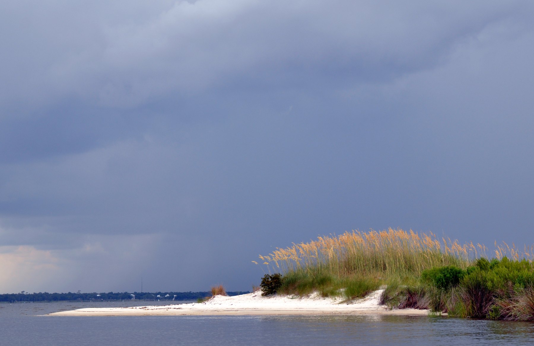 View larger ↗
Tidal Creek Cut On Deer Island — photographed 2014-08-28. Historical image; not current conditions. Photo: Whit Andrews.
Taken: 2014-08-28Tidal Creek Cut On Deer Island · Whit Andrews · CC BY 2.0
Resized/cropped for display; original colors retained. Adaptations retain the stated license.
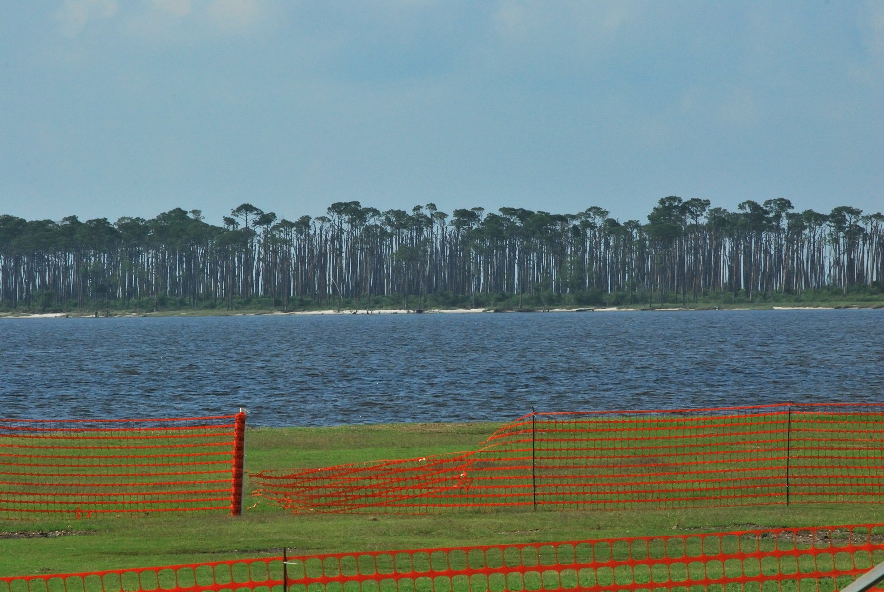 View larger ↗
Deer Island from Point Cadet — photographed 2010-05-22. Historical image; not current conditions. Photo: /\ \/\ /\ / rainchurch.
Taken: 2010-05-22Deer Island from Point Cadet · /\ \/\ /\ / rainchurch · CC BY-SA 2.0
Resized/cropped for display; original colors retained. Adaptations retain the stated license.
Food, stays & rentals
EXTEND YOUR BEACH DAY
Food & drink nearby
Local dining recommendations
Biloxi mainland options before or after the boat trip; no island restaurant or lodging implied.
Restaurant & bar
Shaggy’s Biloxi Beach
Biloxi mainland options before or after the boat trip; no island restaurant or lodging implied. Biloxi Soundfront restaurant; separate trip from Back Bay Hiller Park or Deer Island.
Biloxi Soundfront restaurant; separate trip from Back Bay Hiller Park or Deer Island.
Visit Shaggy’s Biloxi Beach website ↗Website & source check
Website checked ↗ · checked 2026-10-07. Direct individual business and exact city location reviewed. Check current availability with provider. No measured travel time, public parking entitlement or affiliate arrangement established.
Restaurant & bar
Cora’s Restaurant & Bar
Biloxi mainland options before or after the boat trip; no island restaurant or lodging implied. At White House Hotel on Biloxi Soundfront; separate city dining from island or Back Bay park.
At White House Hotel on Biloxi Soundfront; separate city dining from island or Back Bay park.
Visit Cora’s Restaurant & Bar website ↗Website & source check
Website checked ↗ · Supporting source 2 ↗ · checked 2026-10-07. Direct individual business and exact city location reviewed. Check current availability with provider. No measured travel time, public parking entitlement or affiliate arrangement established.
Research notes & location scope
Biloxi mainland options before or after the boat trip; no island restaurant or lodging implied.
Supporting research source ↗ · Supporting research source ↗ · reviewed 2026-10-07
These listings are unpaid and contain no affiliate links.
Accommodations by the beach
Biloxi mainland options before or after the boat trip; no island restaurant or lodging implied. Booking a property does not establish public shoreline access.
Hotel
The White House Hotel
Biloxi mainland options before or after the boat trip; no island restaurant or lodging implied. Biloxi Soundfront hotel; separate from Hiller Park Back Bay and Deer Island arrivals.
Biloxi Soundfront hotel; separate from Hiller Park Back Bay and Deer Island arrivals.
Visit The White House Hotel website ↗Website & source check
Website checked ↗ · Supporting source 2 ↗ · checked 2026-10-07. Direct individual business and exact city location reviewed. Check current availability with provider. No measured travel time, public parking entitlement or affiliate arrangement established.
Before you book
Confirm the exact property or rental unit, view category, beach route, accessibility and total price directly. Nearby lodging does not establish access to a private beach, a boat transfer or permission to camp.
Research notes & location scope
Biloxi mainland options before or after the boat trip; no island restaurant or lodging implied. Booking a property does not establish public shoreline access.
Supporting research source ↗ · reviewed 2026-10-07
These listings are unpaid and contain no affiliate links.
Activities & rentals
Ferry transport and mainland scuba training are distinct from guided offshore snorkeling. No offshore excursion availability or continuous beach snorkeling route inferred.
Biloxi Boat Tours
Deer Island ferry and sightseeing tours; no guided snorkeling/scuba offering established. Operator booking does not override coastal-preserve landing rules.
Visit Biloxi Boat Tours website ↗Source and scope check
Operator source ↗ · checked 2026-10-07T14:10:40.390Z. Deer Island ferry and sightseeing tours; no guided snorkeling/scuba offering established. Operator booking does not override coastal-preserve landing rules.
Direct operator links; no affiliate arrangement is established. Boat excursions do not establish shore snorkeling or a public launch.
Explore nearby beaches
Sources & review date
Guide desk research reviewed 2026-10-07; this is not a field-by-field current verification or an on-site inspection. Official facts, dated agency evidence and editorial assessments retain their own scope. Unknowns and conflicts remain open. Methodology · Rating explanations · Correction history
- Deer Island · identity location ↗
- Deer Island · summary description ↗
- Deer Island · known for ↗
- Deer Island · public access ↗
- Deer Island · sand shoreline ↗
- Deer Island · dogs ↗
- Deer Island · driving ↗
- Deer Island · hours ↗
- Deer Island · camping rules ↗
- Deer Island · fire rules ↗
- Deer Island · shore fishing rules ↗
- Deer Island · public access rules ↗
- Deer Island · managing authority ↗
- Deer Island · closer look ↗
- Deer Island · wildlife ↗
- Deer Island · official source links ↗
- Deer Island · plan your visit ↗
- Deer Island · check before you go ↗
- Deer Island · nearby beaches ↗
- Deer Island · accommodations ↗
- Deer Island · dining ↗
- Deer Island · commercial activities rentals ↗
- Deer Island · photo gallery ↗
- Deer Island · main photo ↗
Photo: Tidal Creek Cut On Deer Island by Whit Andrews · CC BY 2.0. Cropped for display; adaptations retain this license.
Visitor experiences
Original, moderated reviews and photographs. Visit dates and entrances provide context; visitor ratings and reports do not replace official facts or current conditions.
Read approved visitor experiences here when available.