

Somerset County coastal shores · Maryland
Janes Island Beach / Flatcap Beach
Boat-only Chesapeake beach access through Janes Island State Park, with saltmarsh water trails and a dock-to-beach approach at Flatcap. Mainland facilities remain a separate part of the trip.
Good fit: A boat-arranged island-beach visit paired with the park’s saltmarsh water-trail setting. Details & sources ↗
Plan around: Plan the Flatcap landing and return separately from mainland facilities. Daugherty Creek Canal is not a swimming area, and mainland accessibility does not establish island transfer or sand access. Details & sources ↗
- Parking
- Mainland parking; boat trip required
Details & sources
Mainland parking; boat trip requiredDetails & restrictionsJanes Island Beach / Flatcap Beach · parking entry ↗ - Dogs
- Leashed dogs on island
Details & sources
Leashed dogs on island
Read the scoped dogs details and sources
Janes Island Beach / Flatcap Beach · dogs ↗ - Restrooms
- Facilities unconfirmed · see details
Details & sources
Facilities unconfirmed · see details
Read the scoped restrooms details and sources
Janes Island Beach / Flatcap Beach · restrooms showers ↗ - Lifeguards
- No
Details & sources
- Key restrictions
- Check before you go
- Best for
- See beach overview
More planning facts: access, driving & fees
- Public access
- Public accessDetails & restrictions
- Beach driving
- Driving permission unconfirmedDetails & restrictions
- Accessibility
- Route details unconfirmedDetails & restrictions
Choose an entrance
Janes Island designated water-trail landing and island crossing to Tangier Sound shore
The current park permits swimming only on Tangier Sound side beaches, accessible only by boat. The Yellow Trail leads from the mainland marina through Ward Creek to the island dock at Flatcap Basin, then Flat Cap Beach.
Official route / restriction details ↗Review dates & updates
These are desk-research dates for each named category, including unresolved facts. They are not on-site inspections, current-opening confirmations or water-safety observations.
- identity location: research reviewed 2026-10-27 · verified
- summary description: research reviewed 2026-10-27 · verified
- known for: research reviewed 2026-10-27 · verified
- live weather: research reviewed 2026-10-27 · unresolved
- daily forecast: research reviewed 2026-10-27 · unresolved
- tides: research reviewed 2026-10-27 · verified
- surf rip forecast: research reviewed 2026-10-27 · verified
- official flags closures: research reviewed 2026-10-27 · verified
- water quality: research reviewed 2026-10-27 · verified
- public access: research reviewed 2026-10-27 · verified
- crowds: research reviewed 2026-10-27 · unresolved
- sand shoreline: research reviewed 2026-10-27 · verified
- surf: research reviewed 2026-10-27 · unresolved
- shelling: research reviewed 2026-10-27 · verified
- shark teeth: research reviewed 2026-10-27 · unresolved
- sea glass: research reviewed 2026-10-27 · unresolved
- driftwood: research reviewed 2026-10-27 · unresolved
- snorkeling: research reviewed 2026-10-27 · unresolved
- scuba: research reviewed 2026-10-27 · unresolved
- wildlife: research reviewed 2026-10-27 · verified
- accommodations: research reviewed 2026-10-27 · verified
- commercial activities rentals: research reviewed 2026-10-27 · verified
- alcohol rules: research reviewed 2026-10-27 · verified
- fire rules: research reviewed 2026-10-27 · verified
- camping rules: research reviewed 2026-10-27 · verified
- shore fishing rules: research reviewed 2026-10-27 · verified
- hours: research reviewed 2026-10-27 · verified
- dogs: research reviewed 2026-10-27 · verified
- lifeguards: research reviewed 2026-10-27 · verified
- restrooms showers: research reviewed 2026-10-27 · unresolved
- parking entry: research reviewed 2026-10-27 · verified
- accessibility: research reviewed 2026-10-27 · unresolved
- driving: research reviewed 2026-10-27 · unresolved
- public access rules: research reviewed 2026-10-27 · verified
- dining: research reviewed 2026-10-27 · unresolved
- history: research reviewed 2026-10-27 · verified
- managing authority: research reviewed 2026-10-27 · verified
- official source links: research reviewed 2026-10-27 · verified
- main photo: research reviewed 2026-10-27 · unresolved
- photo gallery: research reviewed 2026-10-27 · unresolved
- admission payment passes: research reviewed 2026-10-27 · verified
- plan your visit: research reviewed 2026-10-27 · verified
- check before you go: research reviewed 2026-10-27 · verified
- nearby beaches: research reviewed 2026-10-27 · verified
- closer look: research reviewed 2026-10-27 · verified
Parking, route & accessibility evidence
Parking & entry: Mainland parking; boat trip required. Drive to the mainland park at 26280 Alfred J. Lawson Drive, then arrange your boat journey. The mainland ramp and parking do not provide a walk-on route to the island beach.
Parking source ↗Accessibility: Route details unconfirmed. The mainland park has accessible restrooms, designated campsites and dock-area facilities. These do not establish accessible boat transfer, island dock landing or a continuous route through sand to the water.
Accessibility source ↗Open the county entrance directory ↗
Use the directory to check each entrance’s identity and status. Guide map pins are approximate shoreline locations, not turn-by-turn entrance directions or proof of current opening.
Known for
Isolated island sand and saltmarsh paddling. The current park page describes five miles of beach; its older trail map says six. Treat length as approximate and do not infer a surveyed continuous public boundary.
Rules & facilities
Check before you go
Confirm weather, tide planning, rentals, Flatcap landing, any temporary postings and county water advisories. Island beach and mainland facilities have different access and service scope.
Admission, payment & passes
Day-use park entry is free. The mainland boat ramp costs $7 for Maryland residents and $9 for others; canoe/kayak soft launching is free. Rentals and reserved camping are separate costs.
What to bring & supporting visit details
Plan your visit
Arrange boat access and return before leaving the mainland, use the park’s current trail map, and confirm the Flatcap dock and route. Pack water and sun/insect protection; mainland toilets do not prove island facilities.
Public or private?
Public access
Who can visit: Visitors who arrange lawful boat access and the island crossing.
Entry route, fees & access boundaries
- Manager / access authority
- Maryland Department of Natural Resources, Maryland Park Service, Janes Island State Park. Current phone 410-968-1565 and park email are the responsible access-routing sources.
- Access basis
- The cited source identifies this named shore and its access arrangement.
- Where to enter
- The current park permits swimming only on Tangier Sound side beaches, accessible only by boat. The Yellow Trail leads from the mainland marina through Ward Creek to the island dock at Flatcap Basin, then Flat Cap Beach.
- Fees & reservations
- Day-use park entry is free. The mainland boat ramp costs $7 for Maryland residents and $9 for others; canoe/kayak soft launching is free. Rentals and reserved camping are separate costs.
- Restrictions & exceptions
- No swimming in Daugherty Creek Canal. Use the island beach route and follow current park postings; hunting areas, primitive campsites and other island shorelines retain their own rules.
- What this label covers
- The named coastal shore and its documented arrival. Adjoining private property, current opening, water use and facilities retain separate source scope.
Beach ownership, the route across land, public shoreline-use rights and access to facilities are separate questions. Rules vary by state and location. Use the identified public entrance or documented permission; neither a nearby resort nor an admission fee by itself establishes that a beach is private. A mapped beach is not permission to cross private property.
Access policy reviewed 2026-10-27T13:29:12.590566+00:00. Not a live closure report or a property-boundary survey.
Allowed & prohibited activities
Alcohol: Maryland Park Service prohibits possession or consumption in non-designated park areas. Picnic-shelter permits and certain enclosed lodging exceptions do not authorize drinking on the island beach.
Fires and grills: A fire outside a designated fire area requires a park permit. A mainland campsite fire ring or picnic grill is not a beach-fire permit.
Overnight camping: Use reserved mainland campsites or authorized backcountry campsites and required park permits; the presence of sand does not allow unreserved beach camping.
Shore fishing: Janes Island fishing generally requires a Maryland Chesapeake Bay and Coastal Sport license. The park’s license-free Daugherty canal bulkhead is a specific mainland exception requiring free saltwater registration, not the island beach.
- Hours
- Hours & seasonal limits
Park day-use hours are sunrise to sunset. Ask the park about specifically permitted activities outside those hours; late boat access is not blanket beach opening.
Janes Island Beach / Flatcap Beach · hours ↗ - Dogs on the beach
- Leashed dogs on island
Dogs are allowed on the island under the park’s leash-and-control rule. This does not create an off-leash beach; confirm transport and any posted local restrictions.
Janes Island Beach / Flatcap Beach · dogs ↗ - Lifeguards
- No island lifeguards
No lifeguards on the island’s swimming beaches. An older PDF’s mainland playground/lifeguard description conflicts with the current boat-only unguarded rule and is not used.
Janes Island Beach / Flatcap Beach · lifeguards ↗ - Restrooms
- Facilities unconfirmed · see details
Accessible restrooms and campground bathhouses with hot showers are described on the mainland. An operating toilet or shower at Flatcap Beach itself has not been verified; use mainland facilities before crossing.
Janes Island Beach / Flatcap Beach · restrooms showers ↗ - Access & beach rules
- Rules & restrictions
No swimming in Daugherty Creek Canal. Use the island beach route and follow current park postings; hunting areas, primitive campsites and other island shorelines retain their own rules.
Janes Island Beach / Flatcap Beach · public access rules ↗ - Beach driving
- Driving permission unconfirmed
No beach-driving permit or vehicle-access zone has been established; use the documented arrival area and do not assume permission to drive on sand.
Janes Island Beach / Flatcap Beach · driving ↗
Conditions & activities Surf, sand, wildlife and suitability
Conditions at the beach
Local times use Eastern Time. No beach observation or saved forecast is displayed here. Forecast issue times, observation times, tide prediction dates and laboratory sample dates remain separate from desk-research dates. A linked source does not confirm current opening, a warning flag or swimming safety.
Weather observation
No exact on-beach weather observation or observation station is assigned here. The linked National Weather Service page provides forecast navigation; a forecast is a prediction, not an observed beach condition.
Daily forecast
The independently checked National Weather Service point-forecast link is available for this approximate planning point. No saved numeric forecast is displayed here. Forecast issue and prediction times are separate from source review and are not on-beach observations.
High & low tides
NOAA Crisfield station 8571091 is a regional Little Annemessex River tide-planning reference. Local timing and depths at this beach may differ; predictions do not measure current beach conditions.
Surf & rip forecast
Tangier Sound’s National Weather Service marine forecast describes regional winds, waves and marine hazards. It is not an Atlantic surf forecast or a beach-specific rip-current observation.
Closures & warning flags
Check current Janes Island alerts and county health advisories before departure. The park currently warns about biting insects and closed full-service cabins; neither says all island beach access is closed.
Water quality
Somerset Health identifies this as one of its four bathing-beach monitoring locations. Check its linked Maryland beach advisory system before swimming. No current laboratory result or all-clear is asserted in this guide.
National Weather Service point forecast ↗ for the independently reviewed approximate planning point.
Crowd meter
No reliable beach-specific crowd schedule has been established. Plan around available parking and posted access.
Sand & sandcastles
The park map describes white sand at Flat Cap Beach on the island’s western side. Shoreline and landings can change; the old map is not proof of today’s route dimensions.
Surfing profile
An Atlantic-style surf suitability rating has not been established for this estuarine shore. Consult the regional marine forecast and local conditions.
Beachcombing
The official Flat Cap trail guide describes beachcombing on its sand, without establishing a guaranteed shell yield. State park rules restrict removal or disturbance of plants, rocks, minerals and animals; ask the park about any shell-collection exception rather than assuming souvenirs may be taken.
No reliable evidence establishes this beach as a shark-tooth destination.
Snorkeling & scuba diving
No verified shore-snorkeling route, typical underwater visibility or beach-entry suitability has been established. Suitability remains unrated.
No verified shore-dive route or offshore dive excursion departing this beach has been established. Suitability remains unrated.
Clothing-optional, nudity & topless sunbathing
No clothing-optional designation is verified. State park rules prohibit indecent exposure; the rule does not supply a separate female-topless interpretation. The guide does not list the beach as a verified nude destination.
Separate permission for female-topless sunbathing has not been verified for this beach; it is not listed as a verified topless destination.
Water clarity & shore snorkeling
Typical clarity: Not yet assessed. Typical underwater clarity has not been assessed for this named shore. Water color, bacterial results and forecasts do not measure visibility.
Shore snorkeling not yet assessed. No verified shore-snorkeling route, typical underwater visibility or beach-entry suitability has been established. Suitability remains unrated.
Typical clarity describes how easily you may see through the water. It does not establish bacterial water quality, safe swimming, calm conditions or visibility today.
Evidence, location scope & review
Desk review 2026-10-27T13:29:12.590566+00:00 · Janes Island Beach / Flatcap Beach. This is not an on-site inspection or a current conditions report.
Janes Island Beach / Flatcap Beach
Find clear-water and shore-snorkeling options ↗ · Report a change ↗
Shore & sky wildlife
Janes Island’s marsh and beach habitats support birds, fish and crabs. Its official trail guide specifically discusses tiger beetles, periwinkles, marsh/fiddler/blue crabs and soft-shell clams; observe without handling or disturbing wildlife.
History & interesting facts
The park’s trail guide describes earlier island farms near the Acre and families relocating after high tides and storms. This is island history, not a surviving publicly accessible structure or a current safe landing.
A closer look
Photos of this beach and its surroundings. Select a photo to view it larger. These are recorded views, not live conditions.
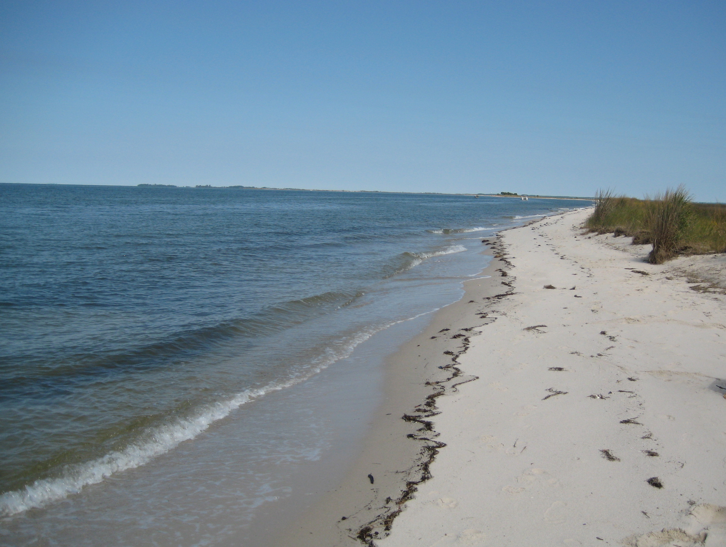 View larger ↗
See the main photograph’s scene caption
Taken: 2009-09-19Beach at Jane's Island · Bonnie Bogle · CC BY 2.0
Resized/cropped for display; original colors retained. Adaptations retain the stated license.
Food, stays & rentals
EXTEND YOUR BEACH DAY
Food & drink nearby
Local dining recommendations
Check separately operated nearby dining before travel; no current food service on this beach has been verified.
Research notes & location scope
Check separately operated nearby dining before travel; no current food service on this beach has been verified.
Supporting research source ↗ · research reviewed 2026-10-27
These listings are unpaid and contain no affiliate links.
Accommodations by the beach
Mainland campsites and mini-cabins are separately reserved. Full-service cabins are currently closed for renovations, with no completion date promised by the current park page. Primitive island camping requires park arrangements.
Before you book
Confirm the exact property or rental unit, view category, beach route, accessibility and total price directly. Nearby lodging does not establish access to a private beach, a boat transfer or permission to camp.
Research notes & location scope
Mainland campsites and mini-cabins are separately reserved. Full-service cabins are currently closed for renovations, with no completion date promised by the current park page. Primitive island camping requires park arrangements.
Supporting research source ↗ · reviewed 2026-10-27
These listings are unpaid and contain no affiliate links.
Activities & rentals
The park offers canoe/kayak rentals seasonally and as weather allows. Confirm availability, equipment, suitable route and return time before relying on a rental to reach Flatcap.
Explore nearby beaches
Sources & review date
Guide desk research reviewed 2026-10-27T13:29:12.590566+00:00; this is not a field-by-field current verification or an on-site inspection. Official facts, dated agency evidence and editorial assessments retain their own scope. Unknowns and conflicts remain open. Methodology · Rating explanations · Correction history
- Janes Island Beach / Flatcap Beach · identity location ↗
- Janes Island Beach / Flatcap Beach · summary description ↗
- Janes Island Beach / Flatcap Beach · known for ↗
- Janes Island Beach / Flatcap Beach · live weather ↗
- Janes Island Beach / Flatcap Beach · daily forecast ↗
- Janes Island Beach / Flatcap Beach · tides ↗
- Janes Island Beach / Flatcap Beach · surf rip forecast ↗
- Janes Island Beach / Flatcap Beach · official flags closures ↗
- Janes Island Beach / Flatcap Beach · water quality ↗
- Janes Island Beach / Flatcap Beach · public access ↗
- Janes Island Beach / Flatcap Beach · crowds ↗
- Janes Island Beach / Flatcap Beach · sand shoreline ↗
- Janes Island Beach / Flatcap Beach · surf ↗
- Janes Island Beach / Flatcap Beach · shelling ↗
- Janes Island Beach / Flatcap Beach · shark teeth ↗
- Janes Island Beach / Flatcap Beach · sea glass ↗
- Janes Island Beach / Flatcap Beach · driftwood ↗
- Janes Island Beach / Flatcap Beach · snorkeling ↗
- Janes Island Beach / Flatcap Beach · scuba ↗
- Janes Island Beach / Flatcap Beach · wildlife ↗
- Janes Island Beach / Flatcap Beach · accommodations ↗
- Janes Island Beach / Flatcap Beach · commercial activities rentals ↗
- Janes Island Beach / Flatcap Beach · alcohol rules ↗
- Janes Island Beach / Flatcap Beach · fire rules ↗
- Janes Island Beach / Flatcap Beach · camping rules ↗
- Janes Island Beach / Flatcap Beach · shore fishing rules ↗
- Janes Island Beach / Flatcap Beach · hours ↗
- Janes Island Beach / Flatcap Beach · dogs ↗
- Janes Island Beach / Flatcap Beach · lifeguards ↗
- Janes Island Beach / Flatcap Beach · restrooms showers ↗
- Janes Island Beach / Flatcap Beach · parking entry ↗
- Janes Island Beach / Flatcap Beach · accessibility ↗
- Janes Island Beach / Flatcap Beach · driving ↗
- Janes Island Beach / Flatcap Beach · public access rules ↗
- Janes Island Beach / Flatcap Beach · dining ↗
- Janes Island Beach / Flatcap Beach · history ↗
- Janes Island Beach / Flatcap Beach · managing authority ↗
- Janes Island Beach / Flatcap Beach · official source links ↗
- Janes Island Beach / Flatcap Beach · main photo ↗
- Janes Island Beach / Flatcap Beach · photo gallery ↗
- Janes Island Beach / Flatcap Beach · admission payment passes ↗
- Janes Island Beach / Flatcap Beach · plan your visit ↗
- Janes Island Beach / Flatcap Beach · check before you go ↗
- Janes Island Beach / Flatcap Beach · nearby beaches ↗
- Janes Island Beach / Flatcap Beach · closer look ↗
Photo: Beach at Jane's Island by Bonnie Bogle · CC BY 2.0. Cropped for display; adaptations retain this license.
Visitor experiences
Original, moderated reviews and photographs. Visit dates and entrances provide context; visitor ratings and reports do not replace official facts or current conditions.
Read approved visitor experiences here when available.