
Pinellas County Bay and River Shores · Florida
Dunedin Causeway Beach
- State
- Florida
- County
- Pinellas County
- City / community
- Dunedin
Tampa Bay and Gulf Coast · Pinellas County Bay and River Shores
A free causeway sand-and-waterfront outing with paddlesports rentals. Traffic, tidal launching and separate dog restrictions are the tradeoffs.
Good fit: A free causeway sand-and-waterfront outing with paddlesports rentals. Traffic, tidal launching and separate dog restrictions are the tradeoffs.
Plan around: The September 2026 ordinance restricts motorized launching on the south shore; check the permitted launch side and current signs.
PLAN THE BASICS
At a glance
- Dogs
- NoDetails & restrictions
- Restrooms
- Unknown · clarification pendingDetails & restrictions
- Lifeguards
- Unknown · clarification pendingDetails & restrictions
- Public access
- Public accessDetails & restrictions
- Beach driving
- NoDetails & restrictions
Choose an entrance
61 Causeway Boulevard, Dunedin
Public source identifies this arrival; Named Dunedin Causeway Beach shoreline only. No surveyed outer boundary, private crossing, or neighboring shoreline membership is asserted.
Official route / restriction details ↗Parking, route & accessibility evidence
Parking & entry: Causeway parking is free. Overnight car/trailer permits are a separate service and do not permit camping.
Parking source ↗Accessibility: The paved trail is not a verified continuous accessible route across the causeway sand to the water.
Accessibility source ↗Open the county entrance directory ↗
Use the directory to check each entrance’s identity and status. Guide map pins are approximate shoreline locations, not turn-by-turn entrance directions or proof of current opening.
Known for
A bay shoreline outing with the specific park or launch context described below.
Sources & review dates
known for
Source ↗ · reviewed 2026-10-05
The September 2026 ordinance restricts motorized launching on the south shore; check the permitted launch side and current signs.
Rules & facilities
Check before you go
The September 2026 ordinance restricts motorized launching on the south shore; check the permitted launch side and current signs.
Sources & review dates
check before you go
Source ↗ · reviewed 2026-10-05
Admission, payment & passes
Sources & review dates
admission payment passes
Source ↗ · reviewed 2026-10-05
What to bring & supporting visit details
Plan your visit
A free causeway sand-and-waterfront outing with paddlesports rentals. Traffic, tidal launching and separate dog restrictions are the tradeoffs. See the entrance section for parking and entry details and sources. Choose the signed arrival before driving.
Sources & review dates
plan your visit
Source ↗ · reviewed 2026-10-05
Public or private?
Public access
Who can visit: Open to the general public, including visitors, during permitted hours and subject to posted rules.
Entry route, fees & access boundaries
- Manager / access authority
- City of Dunedin
- Access basis
- This listing covers a publicly managed beach access or park, not a private guest-only beach.
- Where to enter
- Use 61 Causeway Boulevard, Dunedin. Neighboring hotel lots, private land and differently governed shores are not included.
- Fees & reservations
- See the entrance section for parking and entry details and sources.
- Restrictions & exceptions
- Named Dunedin Causeway Beach shoreline only. No surveyed outer boundary, private crossing, or neighboring shoreline membership is asserted. Use posted public walkovers; a parking or hotel restriction is not proof of a beach-wide pedestrian ban.
- What this label covers
- Named shoreline and supported arrival only; public access is separate from temporary closure.
Beach ownership, the route across land, public shoreline-use rights and access to facilities are separate questions. Rules vary by state and location. Use the identified public entrance or documented permission; neither a nearby resort nor an admission fee by itself establishes that a beach is private. A mapped beach is not permission to cross private property.
Access policy reviewed 2026-10-05. Not a live closure report or a property-boundary survey.
Allowed & prohibited activities
Alcohol: Alcohol rules are not confirmed for this beach.
What still needs confirmation
A current exact beach alcohol rule is not established in the reviewed primary page; do not treat the absence of wording as permission.
Fires and grills: Any permitted fire or grill areas still need confirmation. Follow the restrictions stated here.
What still needs confirmation
A designated cooking grill does not establish permission for an open beach fire; exact beach fire permission is not established.
Overnight camping: Camping is prohibited. An overnight car/trailer permit does not authorize camping.
Shore fishing: Florida saltwater licensing rules do not grant access or override posted swimming-zone and preserve exclusions. Confirm a lawful fishing position at the exact arrival.
Sources & review dates
Alcohol · Fires and grills · Overnight camping
Source ↗ · reviewed 2026-10-05
Shore fishing
Source ↗ · Additional source ↗ · reviewed 2026-10-05
- Hours
- 5 a.m. to 11 p.m.; after-hours presence requires permission under the city rules.Dunedin Causeway Beach · hours evidence ↗
- Dogs on the beach
- Dogs are prohibited on the sandy beach. On the Pinellas Trail they must be on a leash no longer than 6 feet.Dunedin Causeway Beach · dogs evidence ↗
- Lifeguards
- The city causeway page does not publish a lifeguard season or tower roster; this is a launching shoreline, not confirmed guarded swimming.Dunedin Causeway Beach · lifeguards evidence ↗
- Restrooms
- The causeway page does not identify the current restroom and rinse facilities serving each shore launch; ask before relying on them.Dunedin Causeway Beach · restrooms showers evidence ↗
- Access & beach rules
- Named Dunedin Causeway Beach shoreline only. No surveyed outer boundary, private crossing, or neighboring shoreline membership is asserted. Use posted public walkovers; a parking or hotel restriction is not proof of a beach-wide pedestrian ban.Dunedin Causeway Beach · public access rules evidence ↗
- Beach driving
- Use designated roads and authorized parking only. No driving-on-beach permission is established for this arrival.Dunedin Causeway Beach · driving evidence ↗
Conditions & activities Surf, sand, wildlife and suitability
Conditions at the beach
Saved reports below are dated snapshots, not live conditions. JavaScript refreshes them from official sources when available. Source timestamps and tide times identify their time zone.
Weather observation
No usable dated snapshot available. Follow the official source link for updated information.
UV forecast
No current-hour UV estimate is shown in this saved page. Use sun protection; the live forecast loads when available.
Daily forecast
No usable dated snapshot available. Follow the official source link for updated information.
High & low tides
Saved prediction · not live. This dated snapshot may be out of date. Check the official source before your visit.
DUNEDIN CITY DOCK. Named regional NOAA tide prediction reference; not on-beach observed water level, flag, swimming assessment or boat-passage advice. Predictions, not measured water levels or safe crossing times.
- 2026-10-05 02:08 · Low tide
- 2026-10-05 08:02 · High tide
- 2026-10-05 15:45 · Low tide
- 2026-10-05 22:43 · High tide
- 2026-10-06 03:29 · Low tide
- 2026-10-06 09:30 · High tide
- 2026-10-06 16:32 · Low tide
- 2026-10-06 23:01 · High tide
Prediction dates: 2026-10-05–2026-10-06 · station local time.
Retrieved: 2026-10-05T16:10:35.753Z.
Live-use expiration: 2026-10-06T16:10:35.753Z. This static copy never certifies current conditions.
DUNEDIN CITY DOCK. Named regional NOAA tide prediction reference; not on-beach observed water level, flag, swimming assessment or boat-passage advice. Predictions, not measured water levels or safe crossing times.
NOAA tide station ↗NOAA swim & rip-current forecast
Saved report · not live. This dated snapshot may be out of date. Check the official source before your visit.
Forecast rip-current risk: Low · Coastal Charlotte and Coastal Lee
- 1 foot or less.
- In the lower 80s.
- Southeast winds around 5 mph, becoming
- Regional Gulf forecast, not an observed flag or bay swimming assessment.
Source issued/updated: 2026-10-05T07:32:00+00:00.
Retrieved: 2026-10-05T16:10:25.017Z.
Live-use expiration: 2026-10-05T20:30:00.000Z. This static copy never certifies current conditions.
Forecast risk is not the flag flying at this beach. Conditions can vary within the forecast area.
Official local flag & condition status
Flag color: not currently verified
Check the named entrance, posted flags and closures. No dated observed flag connector is connected. Regional forecasts do not establish bay/Gulf swimming safety, lawful landing or current opening.
The Beach Database does not convert weather or a rip-current forecast into a colored flag. Check flags and signs on arrival and ask a lifeguard where available.
Weather warnings & alerts
Saved report · not live. This dated snapshot may be out of date. Check the official source before your visit.
No active NWS area alerts returned at the recorded check. This is not a current all-clear or a beach-closure check.
Source issued/updated: 2026-10-05T16:10:34+00:00.
Retrieved: 2026-10-05T16:10:36.002Z.
Live-use expiration: 2026-10-05T18:10:34.000Z. This static copy never certifies current conditions.
Weather alerts do not confirm swimming safety, lifeguard staffing, water quality or beach closures. No alert does not mean safe water.
Water quality
Only exact active named sample points are linked. Laboratory sample date, observation and retrieval remain distinct; no result establishes present safety along the whole shoreline. Laboratory sample date and retrieval time are separate. A latest available sample is not a current swimming guarantee.
Sources & review dates
water quality
Source ↗ · Additional source ↗ · reviewed 2026-10-05
Crowd meter
Editorial planning: arrive early for parking choice and expect events or good-weather weekends to change the feel; no live crowd measurement is available.
Sources & review dates
crowds
Source ↗ · reviewed 2026-10-05
Sand & sandcastles
This is a bay shoreline; sand, exposed bottom and usable width change with water level and maintenance. No firsthand sand-texture test is claimed.
Sources & review dates
sand shoreline
Source ↗ · reviewed 2026-10-05
Surfing profile
Low suitability: this bay/park shoreline is not established as a conventional Gulf surf-break destination.
Sources & review dates
surf
Source ↗ · reviewed 2026-10-05
Beachcombing
Beachcombing is a viewing activity here unless the managing authority confirms what may be removed; live animals and protected nesting areas are not souvenirs.
No location-specific, reliably documented shark teeth finding pattern was established for Dunedin Causeway Beach; this guide does not promise collectible finds.
Sources & review dates
shelling · shark teeth
Source ↗ · reviewed 2026-10-05
Snorkeling & scuba diving
Low suitability for a planned snorkeling destination: visibility, boat traffic and bathing permission must be checked; no surveyed snorkel route is established.
No surveyed shore-dive entry is established here. County offshore artificial reefs are separate boat-access sites, with their own coordinates and marine planning.
Sources & review dates
snorkeling
Source ↗ · reviewed 2026-10-05
scuba
Source ↗ · Additional source ↗ · reviewed 2026-10-05
Shore & sky wildlife
Observe coastal birds and other wildlife from a distance; no guaranteed sighting or current nesting count is claimed.
Sources & review dates
wildlife
Source ↗ · reviewed 2026-10-05
History & interesting facts
The managing-authority record identifies Dunedin Causeway Beach as a named beach or recreational shoreline. A specific founding-date narrative is not asserted without an exact historical source.
Sources & review dates
history
Source ↗ · reviewed 2026-10-05
A closer look
Photos of this beach and its surroundings. Select a photo to view it larger. These are recorded views, not live conditions.
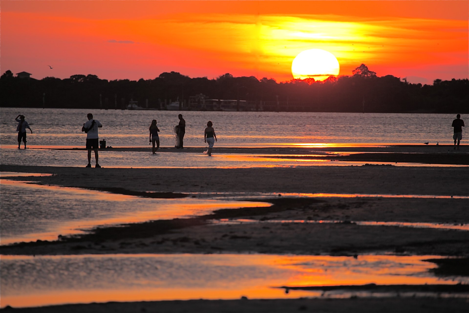 View larger ↗
Dunedin Causeway Beach · L'eau Bleue · CC BY-SA 2.0 · archival photograph; captured 2011-05-30
Taken: 2011-05-30Dunedin Causeway · L'eau Bleue · CC BY-SA 2.0
Resized/cropped for display; original colors retained. Adaptations retain the stated license.
Food, stays & rentals
EXTEND YOUR BEACH DAY
Food & drink nearby
Local dining recommendations
Local dining recommendations: HEW Parlor & Chophouse at Fenway Hotel, 453 Edgewater Drive, is a sit-down Dunedin meal after an island/causeway day. It requires a mainland drive; it is not a beach concession.
Sources & review dates
dining
Source ↗ · reviewed 2026-10-05
Accommodations by the beach
Fenway Hotel at 453 Edgewater Drive offers a Dunedin base with a pool and guest amenities; use a separate transfer to the causeway or state-park ferry.
Sources & review dates
accommodations
Source ↗ · reviewed 2026-10-05
Activities & rentals
Sail Honeymoon at 61 Causeway Boulevard rents kayaks and paddleboards and operates High & Dry Café. Caladesi Island Ferry has ticket-office sales at Honeymoon, weather-dependent hourly departures from 10 a.m., and a return/stay time printed with the trip.
Sources & review dates
commercial activities rentals
Source ↗ · Additional source ↗ · reviewed 2026-10-05
Explore nearby beaches
Sources & review date
Guide desk research reviewed 2026-10-05; this is not a field-by-field current verification or an on-site inspection. Official facts, dated agency evidence and editorial assessments retain their own scope. Unknowns and conflicts remain open. Methodology · Rating explanations · Correction history
- Dunedin Causeway Beach managing authority ↗
- Dunedin Causeway Beach · hours evidence ↗
- Dunedin Causeway Beach · dogs evidence ↗
- Dunedin Causeway Beach · lifeguards evidence ↗
- Dunedin Causeway Beach · restrooms showers evidence ↗
- Dunedin Causeway Beach · public access rules evidence ↗
- Dunedin Causeway Beach · driving evidence ↗
- Dunedin Causeway Beach · parking entry evidence ↗
- Dunedin Causeway Beach · accessibility evidence ↗
- Dunedin Causeway Beach · sand shoreline evidence ↗
- Dunedin Causeway Beach · surf evidence ↗
- Dunedin Causeway Beach · water quality evidence ↗
Photo: Dunedin Causeway by L'eau Bleue · CC BY-SA 2.0. Cropped for display; adaptations retain this license.
Visitor experiences
Original, moderated reviews and photographs. Visit dates and entrances provide context; visitor ratings and reports do not replace official facts or current conditions.
Read approved visitor experiences here when available.