
Manatee County Gulf Coast · Florida
Greer Island
- State
- Florida
- County
- Manatee County
- City / community
- Longboat Key
Southwest Florida Gulf Coast · Manatee County Gulf Coast
Greer Island, often called Beer Can Island, is a rustic shoreline stop for nature views and shelling around Longboat Pass. It is not a full-service swimming beach: currents, tide-dependent route gaps and limited facilities are the tradeoffs.
Good fit: Greer Island, often called Beer Can Island, is a rustic shoreline stop for nature views and shelling around Longboat Pass. It is not a full-service swimming beach: currents, tide-dependent route gaps and limited facilities are the tradeoffs.
Plan around: The exact continuous landward route and any tidal gap remain unverified. Check signed access and tide conditions; do not assume a clear walk from North Shore Road or cross private property.
PLAN THE BASICS
At a glance
- Dogs
- NoDetails & restrictions
- Restrooms
- Unknown · clarification pendingDetails & restrictions
- Lifeguards
- NoDetails & restrictions
- Public access
- Public accessDetails & restrictions
- Beach driving
- NoDetails & restrictions
Choose an entrance
Greer Island northern shoreline approach
Greer Island is the undeveloped northern Longboat shoreline near Longboat Pass. Use only a signed lawful approach from the North Shore area; tidal sand changes can interrupt the walking route. Do not cross private land.
Official route / restriction details ↗Parking, route & accessibility evidence
Parking & entry: Use lawful signed North Shore-area parking only. A listed town lot is not proof of an uninterrupted route around the point.
Parking source ↗Accessibility: A continuous step-free route onto sand has not been established for this exact crossing. Check the surface, stairs and remaining sand gap before relying on access.
Accessibility source ↗Open the county entrance directory ↗
Use the directory to check each entrance’s identity and status. Guide map pins are approximate shoreline locations, not turn-by-turn entrance directions or proof of current opening.
Known for
Natural inlet shoreline, shelling and Longboat Pass scenery.
Sources & review dates
known for
Source ↗ · Additional source ↗ · Additional source ↗ · Additional source ↗ · Additional source ↗ · reviewed 2026-10-05
The exact continuous landward route and any tidal gap remain unverified. Check signed access and tide conditions; do not assume a clear walk from North Shore Road or cross private property.
Rules & facilities
Check before you go
The exact continuous landward route and any tidal gap remain unverified. Check signed access and tide conditions; do not assume a clear walk from North Shore Road or cross private property.
Sources & review dates
check before you go
Source ↗ · Additional source ↗ · Additional source ↗ · Additional source ↗ · Additional source ↗ · reviewed 2026-10-05
Admission, payment & passes
The exact current entry/parking fee is not stated by the reviewed managing-authority source; do not label it free.
Sources & review dates
admission payment passes
Source ↗ · Additional source ↗ · Additional source ↗ · Additional source ↗ · Additional source ↗ · reviewed 2026-10-05
What to bring & supporting visit details
Plan your visit
Greer Island is the undeveloped northern Longboat shoreline near Longboat Pass. Use only a signed lawful approach from the North Shore area; tidal sand changes can interrupt the walking route. Do not cross private land. No currently operating toilet or shower is established on Greer Island itself. Plan for an undeveloped shoreline visit. Bring water and sun protection; check posted restrictions and current alerts.
Sources & review dates
plan your visit
Source ↗ · Additional source ↗ · Additional source ↗ · Additional source ↗ · Additional source ↗ · reviewed 2026-10-05
Public or private?
Public access
Who can visit: Open to the general public, including visitors, during permitted hours and subject to posted rules.
Entry route, fees & access boundaries
- Manager / access authority
- Town of Longboat Key / Manatee County as scoped
- Access basis
- This listing covers a publicly managed beach access or park, not a private guest-only beach.
- Where to enter
- Greer Island is the undeveloped northern Longboat shoreline near Longboat Pass. Use only a signed lawful approach from the North Shore area; tidal sand changes can interrupt the walking route. Do not cross private land.
- Fees & reservations
- The exact current entry/parking fee is not stated by the reviewed managing-authority source; do not label it free.
- Restrictions & exceptions
- Greer Island is the undeveloped northern Longboat shoreline near Longboat Pass. Use only a signed lawful approach from the North Shore area; tidal sand changes can interrupt the walking route. Do not cross private land.
- What this label covers
- Named shoreline and supported arrival only; public access is separate from temporary closure.
Beach ownership, the route across land, public shoreline-use rights and access to facilities are separate questions. Rules vary by state and location. Use the identified public entrance or documented permission; neither a nearby resort nor an admission fee by itself establishes that a beach is private. A mapped beach is not permission to cross private property.
Access policy reviewed 2026-10-05. Not a live closure report or a property-boundary survey.
Allowed & prohibited activities
Alcohol: Alcohol is prohibited on town property, including public beach areas.
Fires and grills: Do not light a beach fire; any designated grill permission must be confirmed at the exact park.
Overnight camping: Overnight beach camping permission is not confirmed.
What still needs confirmation
Town beach camping is prohibited; public accesses also close overnight.
Shore fishing: Town rules allow shore fishing unless posted otherwise. Check closures, swimming activity and applicable licensing.
Sources & review dates
Alcohol · Fires and grills · Overnight camping · Shore fishing
Source ↗ · Additional source ↗ · Additional source ↗ · Additional source ↗ · Additional source ↗ · reviewed 2026-10-05
- Hours
- Town beaches and public accesses close 11 p.m.–5 a.m., unless signs state otherwise.Greer Island · hours evidence ↗
- Dogs on the beach
- Town beaches and beach accesses prohibit animals.Greer Island · dogs evidence ↗
- Lifeguards
- Longboat Key beaches are not monitored by lifeguards.Greer Island · lifeguards evidence ↗
- Restrooms
- No currently operating toilet or shower is established on Greer Island itself. Plan for an undeveloped shoreline visit.Greer Island · restrooms showers evidence ↗
- Access & beach rules
- Greer Island is the undeveloped northern Longboat shoreline near Longboat Pass. Use only a signed lawful approach from the North Shore area; tidal sand changes can interrupt the walking route. Do not cross private land.Greer Island · public access rules evidence ↗
- Beach driving
- Public parking and approach roads are not permission to drive onto beach sand. Use the signed crossing on foot.Greer Island · driving evidence ↗
Conditions & activities Surf, sand, wildlife and suitability
Conditions at the beach
Saved reports below are dated snapshots, not live conditions. JavaScript refreshes them from official sources when available. Source timestamps and tide times identify their time zone.
Weather observation
Saved report · not live. This dated snapshot may be out of date. Check the official source before your visit.
81°F · Clear
- Sarasota / Bradenton, Sarasota-Bradenton International Airport · 13.7 km from destination reference · nearby reporting station, not a beach sensor.
Observation: 2026-10-05T12:55:00+00:00.
Retrieved: 2026-10-05T13:16:24.365Z.
Live-use expiration: 2026-10-05T14:55:00.000Z. This static copy never certifies current conditions.
UV forecast
No current-hour UV estimate is shown in this saved page. Use sun protection; the live forecast loads when available.
Daily forecast
Saved report · not live. This dated snapshot may be out of date. Check the official source before your visit.
Saved forecast for this beach’s NWS grid
- 2026-10-05T09:00:00-04:00–2026-10-05T18:00:00-04:00: Today · 86°F · Scattered Showers And Thunderstorms · wind 7 to 10 mph S
- 2026-10-05T18:00:00-04:00–2026-10-06T06:00:00-04:00: Tonight · 77°F · Scattered Showers And Thunderstorms · wind 6 to 10 mph NE
Source issued/updated: 2026-10-05T10:32:19+00:00.
Retrieved: 2026-10-05T13:16:24.947Z.
Live-use expiration: 2026-10-05T22:00:00.000Z. This static copy never certifies current conditions.
High & low tides
Saved prediction · not live. This dated snapshot may be out of date. Check the official source before your visit.
Cortez, Sarasota Bay. Regional bay/key tide prediction, not an on-beach observation, swimming assessment or safe pass-crossing advice. Predictions, not measured water levels or safe crossing times.
- 2026-10-05 02:06 · Low tide
- 2026-10-05 07:36 · High tide
- 2026-10-05 16:20 · Low tide
- 2026-10-05 23:15 · High tide
- 2026-10-06 03:45 · Low tide
- 2026-10-06 09:15 · High tide
- 2026-10-06 17:07 · Low tide
- 2026-10-06 23:20 · High tide
Prediction dates: 2026-10-05–2026-10-06 · station local time.
Retrieved: 2026-10-05T13:16:24.640Z.
Live-use expiration: 2026-10-06T13:16:24.640Z. This static copy never certifies current conditions.
Cortez, Sarasota Bay. Regional bay/key tide prediction, not an on-beach observation, swimming assessment or safe pass-crossing advice. Predictions, not measured water levels or safe crossing times.
NOAA tide station ↗NOAA swim & rip-current forecast
Saved report · not live. This dated snapshot may be out of date. Check the official source before your visit.
Forecast rip-current risk: Low · Pinellas, Coastal Hillsborough, Coastal Manatee and Coastal Sarasota (combined NWS forecast area)
- 1 foot or less.
- In the lower 80s.
- Southeast winds around 10 mph, becoming
- Regional Gulf forecast, not an observed flag or bay swimming assessment.
Source issued/updated: 2026-10-05T07:32:00+00:00.
Retrieved: 2026-10-05T13:16:23.964Z.
Live-use expiration: 2026-10-05T20:30:00.000Z. This static copy never certifies current conditions.
Forecast risk is not the flag flying at this beach. Conditions can vary within the forecast area.
Official local flag & condition status
Flag color: not currently verified
Check the named entrance, posted flags and current closures. No dated observed flag connector is connected here. Regional forecasts do not establish Gulf/bay swimming safety, lawful landing or current opening.
The Beach Database does not convert weather or a rip-current forecast into a colored flag. Check flags and signs on arrival and ask a lifeguard where available.
Weather warnings & alerts
Saved report · not live. This dated snapshot may be out of date. Check the official source before your visit.
No active NWS area alerts returned at the recorded check. This is not a current all-clear or a beach-closure check.
Source issued/updated: 2026-10-05T13:15:00+00:00.
Retrieved: 2026-10-05T13:16:24.951Z.
Live-use expiration: 2026-10-05T15:15:00.000Z. This static copy never certifies current conditions.
Weather alerts do not confirm swimming safety, lifeguard staffing, water quality or beach closures. No alert does not mean safe water.
Water quality
No exact active sample point has been reconciled for this named shoreline. Coordinate and label conflicts remain unassigned; nearby Gulf, bay and resort samples are not substituted. Check the official Manatee report. Laboratory sample date and retrieval time are separate. A latest available sample is not a current swimming guarantee.
Sources & review dates
water quality
Source ↗ · Additional source ↗ · reviewed 2026-10-05
Crowd meter
A nature-oriented shoreline stop with limited services; a quiet atmosphere is not a promise of an empty beach.
Sources & review dates
crowds
Source ↗ · Additional source ↗ · Additional source ↗ · Additional source ↗ · Additional source ↗ · reviewed 2026-10-05
Sand & sandcastles
Gulf beach sand supports walking and sand play; width and shell content vary with tide, storms and nourishment.
Sources & review dates
sand shoreline
Source ↗ · Additional source ↗ · Additional source ↗ · Additional source ↗ · Additional source ↗ · reviewed 2026-10-05
Surfing profile
Inlet currents and structures make this a poor choice for a beginner swimming or surf lesson.
Sources & review dates
surf
Source ↗ · Additional source ↗ · Additional source ↗ · Additional source ↗ · Additional source ↗ · reviewed 2026-10-05
Beachcombing
The tourism/DEP profile identifies shelling here. Enjoy looking without expecting a guaranteed find and leave living organisms and protected material.
No beach-specific evidence establishes dependable shark-tooth hunting. Do not market it as a fossil destination.
Sources & review dates
shelling · shark teeth
Source ↗ · Additional source ↗ · Additional source ↗ · Additional source ↗ · Additional source ↗ · reviewed 2026-10-05
Snorkeling & scuba diving
This shoreline is not recommended as an entrance-side snorkeling destination. Bay/inlet currents, visibility and boat traffic are tradeoffs; use a separately operated suitable excursion if desired.
No verified shore-dive entry, surveyed underwater route or onsite dive service is established at this entrance. Offshore charter diving is a separate trip.
Sources & review dates
snorkeling · scuba
Source ↗ · Additional source ↗ · Additional source ↗ · Additional source ↗ · Additional source ↗ · reviewed 2026-10-05
Shore & sky wildlife
Respect sea-turtle nesting May–October and posted shorebird areas. Do not disturb nests or wildlife; a beach visit never guarantees a sighting.
Sources & review dates
wildlife
Source ↗ · Additional source ↗ · Additional source ↗ · Additional source ↗ · Additional source ↗ · reviewed 2026-10-05
History & interesting facts
Barrier-island beaches and approaches change through storms, tides and nourishment. The named public crossing is a visitor arrival, not a surveyed shoreline boundary.
Sources & review dates
history
Source ↗ · Additional source ↗ · Additional source ↗ · Additional source ↗ · Additional source ↗ · reviewed 2026-10-05
A closer look
Photos of this beach and its surroundings. Select a photo to view it larger. These are recorded views, not live conditions.
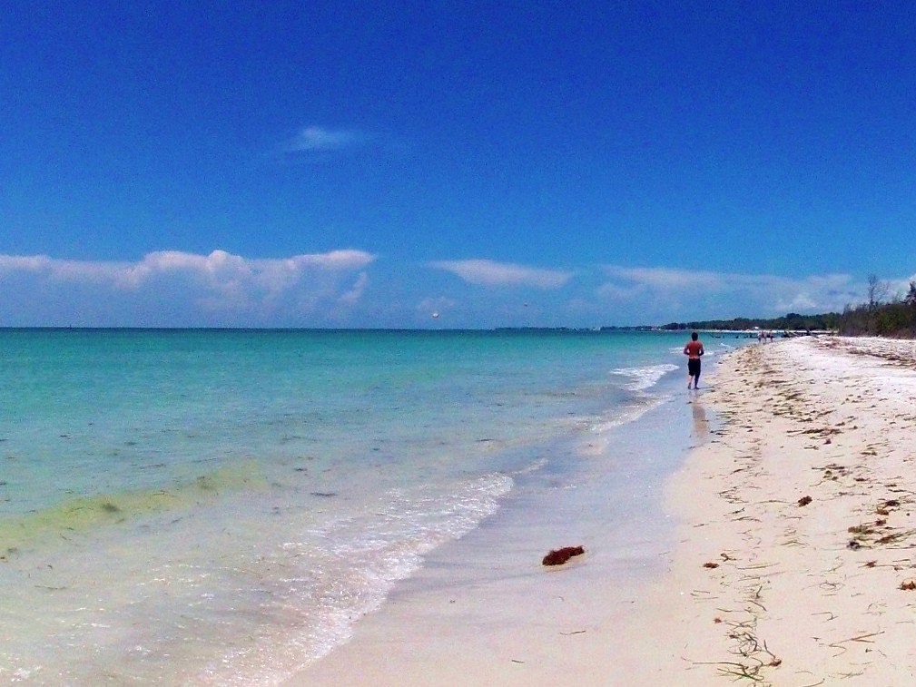 View larger ↗
Greer Island · archival photograph 2012-08-18 12:48:34 · SNORKELINGDIVES.COM · CC BY 2.0
Taken: 2012-08-18 12:48:34Snorkeling at Beer Can Island off Long Boat Key, Florida · SNORKELINGDIVES.COM · CC BY 2.0
Resized/cropped for display; original colors retained. Adaptations retain the stated license.
Food, stays & rentals
EXTEND YOUR BEACH DAY
Food & drink nearby
Local dining recommendations
Local dining recommendations: Harry's Continental Kitchens: 5600 Gulf of Mexico Drive: restaurant, deli and corner-store services for a northern Longboat trip. Not an onsite Greer Island concession. (https://www.harryskitchen.com/)
Sources & review dates
dining
Source ↗ · Additional source ↗ · Additional source ↗ · Additional source ↗ · Additional source ↗ · reviewed 2026-10-05
Accommodations by the beach
Silver Sands Gulf Beach Resort: 5841 Gulf of Mexico Drive: northern Longboat lodging with kitchens and guest beach facilities. The property describes steps to the beach; it is not proof of step-free access. (https://silversandsgulfbeachresort.com/amenities)
Sources & review dates
accommodations
Source ↗ · Additional source ↗ · Additional source ↗ · Additional source ↗ · Additional source ↗ · reviewed 2026-10-05
Activities & rentals
Beach Bums — bikes, kayaks, paddleboards, chairs and umbrellas, beach wagons. 427 Pine Avenue, Anna Maria: equipment hire and vacation-rental delivery for an island stay. Confirm the delivery destination; equipment availability is not permission for commercial setup on any public beach. (https://beachbumsami.com/)
Sources & review dates
commercial activities rentals
Source ↗ · Additional source ↗ · Additional source ↗ · Additional source ↗ · Additional source ↗ · reviewed 2026-10-05
Explore nearby beaches
Sources & review date
Guide desk research reviewed 2026-10-05; this is not a field-by-field current verification or an on-site inspection. Official facts, dated agency evidence and editorial assessments retain their own scope. Unknowns and conflicts remain open. Methodology · Rating explanations · Correction history
- Greer Island managing authority ↗
- Greer Island · hours evidence ↗
- Greer Island · dogs evidence ↗
- Greer Island · lifeguards evidence ↗
- Greer Island · restrooms showers evidence ↗
- Greer Island · public access rules evidence ↗
- Greer Island · driving evidence ↗
- Greer Island · parking entry evidence ↗
- Greer Island · accessibility evidence ↗
- Greer Island · sand shoreline evidence ↗
- Greer Island · surf evidence ↗
- Greer Island · water quality evidence ↗
Photo: Snorkeling at Beer Can Island off Long Boat Key, Florida by SNORKELINGDIVES.COM · CC BY 2.0. Cropped for display; adaptations retain this license.
Visitor experiences
Original, moderated reviews and photographs. Visit dates and entrances provide context; visitor ratings and reports do not replace official facts or current conditions.
Read approved visitor experiences here when available.